Gjinar geodata
Gjinar (Elbasan) is a seat of a third-order administrative division; located in Albania in Europe/Tirane (GMT+2) time zone. In our database, there are 71 cities with bigger population. Compared to other cities in Albania, 51.8% of cities are located further ↑North; 67.3% of cities are located further ←West and 81.7% of cities have lower elevation than Gjinar. Note1


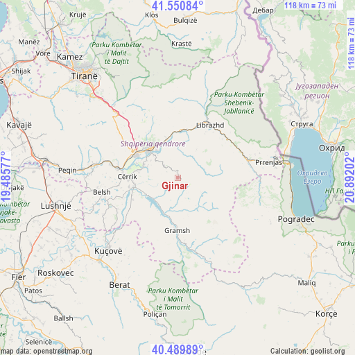
Gjinar GPS coordinates[2]
41° 1' 21" North, 20° 11' 20.004" East
| Map corner | latitude | longitude |
|---|---|---|
| Upper-left | 41.55084°, | 19.48577° |
| Center: | 41.0225°, | 20.18889° |
| Lower-right: | 40.48989°, | 20.89202° |
| Map W x H: | 118×118 km | = 73.3×73.3mi |
| max Lat: | 42.45139° ⇑51.8% North |
| Gjinar: | 41.0225° |
| min Lat: | ⇓48.2% South 39.65889° |
| min Long | Gjinar | max Long |
| 19.40556° | 20.18889° | 20.99° |
| W 67.3%⇐ | ⇒32.7% E |
Elevation
Elevation of Gjinar is 764 m = 2507 ft, and this is 389.4 m = 1278 ft above average elevation for this country.
| Max E: |
1352 m = 4436 ft | 18.3% |
| Gjinar | 764 m 2507 ft | |
| Avg. | 374.6 m = 1229 ft | |
Min E: |
-2 m = -7 ft | 81.7% |
See also: Albania elevation on elevation.city.
Geographical zone
Gjinar is located in North temperate zone (between Tropic of Cancer and the Arctic Circle). Distance of this Northern Tropic circle is 1955.4 km =1215 mi to South.| Distance of | km | miles | from Gjinar |
|---|---|---|---|
| North Pole | 5445.8 | 3383.9 | to North |
| Arctic Circle | 2839.9 | 1764.6 | to North |
| Tropic Cancer | 1955.4 | 1215 | to South |
| Equator | 4561.3 | 2834.3 | to South |


Nearby cities:
15 places around Gjinar: (largest is in red/bold)
• Bradashesh
16.7 km =10.4 mi,  303°
303°
• Elbasan
13.4 km =8.3 mi,  318°
318°
• Gjergjan
13.5 km =8.4 mi,  279°
279°
• Gostimë
14.3 km =8.9 mi,  17°
17°
• Gramsh
17 km =10.6 mi,  181°
181°
• Klos
17.3 km =10.7 mi,  240°
240°
• Labinot-Fushë
13.6 km =8.5 mi,  344°
344°
• Pishaj
15.7 km =9.8 mi, 181°
• Polis-Gostimë
13.6 km =8.5 mi,  25°
25°
• Poroçan
12.8 km =8 mi,  134°
134°
• Shirgjan
11.8 km =7.3 mi,  286°
286°
• Shushicë
9 km =5.6 mi, 337°
• Sult
17.1 km =10.6 mi,  206°
206°
• Tregan
9.3 km =5.8 mi,  271°
271°
• Zavalinë
9 km =5.6 mi,  120°
120°
Sources, notices
• [Note1] Compared only with cities in Albania existing in our database
• [Src1] Map data: © OpenStreetMap contributors (CC-BY-SA)
• [Src2] Other city data from geonames.org with taken over terms of usage.
• [Src3] Geographical zone / Annual Mean Temperature by Robert A. Rohde @ Wikipedia
