Gramsh geodata
Gramsh (Elbasan) is a seat of a second-order administrative division; located in Albania in Europe/Tirane (GMT+2) time zone. With population of 11,556 people, there are 28 cities with bigger population in this country. Compared to other cities in Albania, 60.3% of cities are located further ↑North; 66.8% of cities are located further ←West and 57.5% of cities have higher elevation than Gramsh. Note1


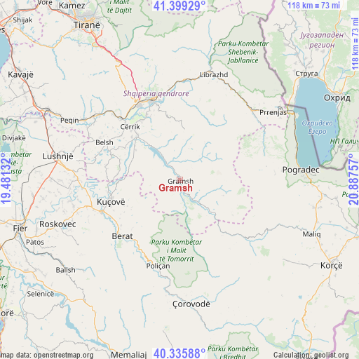
Gramsh GPS coordinates[2]
40° 52' 10.992" North, 20° 11' 3.984" East
| Map corner | latitude | longitude |
|---|---|---|
| Upper-left | 41.39929°, | 19.48132° |
| Center: | 40.86972°, | 20.18444° |
| Lower-right: | 40.33588°, | 20.88757° |
| Map W x H: | 118.2×118.2 km | = 73.4×73.4mi |
| max Lat: | 42.45139° ⇑60.3% North |
| Gramsh: | 40.86972° |
| min Lat: | ⇓39.7% South 39.65889° |
| min Long | Gramsh | max Long |
| 19.40556° | 20.18444° | 20.99° |
| W 66.8%⇐ | ⇒33.2% E |
Elevation
Elevation of Gramsh is 200 m = 656 ft, and this is 174.6 m = 573 ft below average elevation for this country.
| Max E: |
1352 m = 4436 ft | 57.5% |
| Avg. | 374.6 m = 1229 ft | |
| Gramsh | 200 m = 656 ft | |
Min E: |
-2 m = -7 ft | 42.5% |
See also: Albania elevation on elevation.city.
Geographical zone
Gramsh is located in North temperate zone (between Tropic of Cancer and the Arctic Circle). Distance of this Northern Tropic circle is 1938.4 km =1204.5 mi to South.| Distance of | km | miles | from Gramsh |
|---|---|---|---|
| North Pole | 5462.8 | 3394.4 | to North |
| Arctic Circle | 2856.9 | 1775.2 | to North |
| Tropic Cancer | 1938.4 | 1204.5 | to South |
| Equator | 4544.3 | 2823.7 | to South |


Nearby cities:
15 places around Gramsh: (largest is in red/bold)
• Gjinar
17 km =10.6 mi,  1°
1°
• Klos
17 km =10.6 mi,  300°
300°
• Kodovjat
9.1 km =5.7 mi,  141°
141°
• Kukur
15.1 km =9.4 mi,  90°
90°
• Kushovë
9 km =5.6 mi,  177°
177°
• Lenias
20.8 km =12.9 mi,  123°
123°
• Mollas
16.5 km =10.3 mi,  292°
292°
• Pishaj
1.3 km =0.8 mi,  353°
353°
• Poroçan
12.5 km =7.8 mi,  50°
50°
• Roshnik
19.5 km =12.1 mi,  218°
218°
• Skënderbegas
11.4 km =7.1 mi,  155°
155°
• Sult
7.3 km =4.5 mi,  283°
283°
• Tregan
19.4 km =12.1 mi,  332°
332°
• Tunjë
7.3 km =4.5 mi,  237°
237°
• Zavalinë
14.8 km =9.2 mi,  33°
33°
Sources, notices
• [Note1] Compared only with cities in Albania existing in our database
• [Src1] Map data: © OpenStreetMap contributors (CC-BY-SA)
• [Src2] Other city data from geonames.org with taken over terms of usage.
• [Src3] Geographical zone / Annual Mean Temperature by Robert A. Rohde @ Wikipedia
