Poroçan geodata
Poroçan (Elbasan) is a seat of a third-order administrative division; located in Albania in Europe/Tirane (GMT+2) time zone. In our database, there are 71 cities with bigger population. Compared to other cities in Albania, 56.3% of cities are located further ↑North; 75.5% of cities are located further ←West and 82.3% of cities have lower elevation than Poroçan. Note1


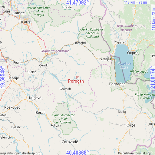
Poroçan GPS coordinates[2]
40° 56' 30.984" North, 20° 17' 54.996" East
| Map corner | latitude | longitude |
|---|---|---|
| Upper-left | 41.47092°, | 19.59549° |
| Center: | 40.94194°, | 20.29861° |
| Lower-right: | 40.40868°, | 21.00174° |
| Map W x H: | 118.1×118.1 km | = 73.4×73.4mi |
| max Lat: | 42.45139° ⇑56.3% North |
| Poroçan: | 40.94194° |
| min Lat: | ⇓43.7% South 39.65889° |
| min Long | Poroçan | max Long |
| 19.40556° | 20.29861° | 20.99° |
| W 75.5%⇐ | ⇒24.5% E |
Elevation
Elevation of Poroçan is 770 m = 2526 ft, and this is 395.4 m = 1297 ft above average elevation for this country.
| Max E: |
1352 m = 4436 ft | 17.7% |
| Poroçan | 770 m 2526 ft | |
| Avg. | 374.6 m = 1229 ft | |
Min E: |
-2 m = -7 ft | 82.3% |
See also: Albania elevation on elevation.city.
Geographical zone
Poroçan is located in North temperate zone (between Tropic of Cancer and the Arctic Circle). Distance of this Northern Tropic circle is 1946.4 km =1209.4 mi to South.| Distance of | km | miles | from Poroçan |
|---|---|---|---|
| North Pole | 5454.7 | 3389.4 | to North |
| Arctic Circle | 2848.9 | 1770.2 | to North |
| Tropic Cancer | 1946.4 | 1209.4 | to South |
| Equator | 4552.3 | 2828.7 | to South |


Nearby cities:
15 places around Poroçan: (largest is in red/bold)
• Gjinar
12.8 km =8 mi,  314°
314°
• Gramsh
12.5 km =7.8 mi,  230°
230°
• Kodovjat
15.7 km =9.8 mi,  194°
194°
• Kukur
9.9 km =6.2 mi,  146°
146°
• Kushovë
19.4 km =12.1 mi,  208°
208°
• Pishaj
11.9 km =7.4 mi,  235°
235°
• Proptisht
17.8 km =11.1 mi,  73°
73°
• Qukës-Skënderbe
19.6 km =12.2 mi,  36°
36°
• Skënderbegas
19.1 km =11.9 mi, 194°
• Stravaj
12.6 km =7.8 mi,  56°
56°
• Sult
17.9 km =11.1 mi,  249°
249°
• Tregan
20.7 km =12.9 mi,  296°
296°
• Tunjë
19.7 km =12.2 mi, 232°
• Velçan
13.8 km =8.6 mi,  84°
84°
• Zavalinë
4.6 km =2.9 mi,  340°
340°
Sources, notices
• [Note1] Compared only with cities in Albania existing in our database
• [Src1] Map data: © OpenStreetMap contributors (CC-BY-SA)
• [Src2] Other city data from geonames.org with taken over terms of usage.
• [Src3] Geographical zone / Annual Mean Temperature by Robert A. Rohde @ Wikipedia
