Çorovodë geodata
Çorovodë (Berat) is a seat of a second-order administrative division; located in Albania in Europe/Tirane (GMT+2) time zone. With population of 14,046 people, there are 25 cities with bigger population in this country. Compared to other cities in Albania, 83.9% of cities are located further ↑North; 70.4% of cities are located further ←West and 54.1% of cities have lower elevation than Çorovodë. Note1


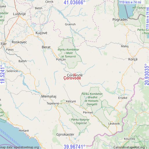
Çorovodë GPS coordinates[2]
40° 30' 15.012" North, 20° 13' 37.992" East
| Map corner | latitude | longitude |
|---|---|---|
| Upper-left | 41.03666°, | 19.5241° |
| Center: | 40.50417°, | 20.22722° |
| Lower-right: | 39.96741°, | 20.93035° |
| Map W x H: | 118.9×118.9 km | = 73.9×73.9mi |
| max Lat: | 42.45139° ⇑83.9% North |
| Çorovodë: | 40.50417° |
| min Lat: | ⇓16.1% South 39.65889° |
| min Long | Çorovodë | max Long |
| 19.40556° | 20.22722° | 20.99° |
| W 70.4%⇐ | ⇒29.6% E |
Elevation
Elevation of Çorovodë is 320 m = 1050 ft, and this is 54.6 m = 179 ft below average elevation for this country.
| Max E: |
1352 m = 4436 ft | 45.9% |
| Avg. | 374.6 m = 1229 ft | |
| Çorovodë | 320 m = 1050 ft | |
Min E: |
-2 m = -7 ft | 54.1% |
See also: Albania elevation on elevation.city.
Geographical zone
Çorovodë is located in North temperate zone (between Tropic of Cancer and the Arctic Circle). Distance of this Northern Tropic circle is 1897.7 km =1179.2 mi to South.| Distance of | km | miles | from Çorovodë |
|---|---|---|---|
| North Pole | 5503.4 | 3419.7 | to North |
| Arctic Circle | 2897.5 | 1800.4 | to North |
| Tropic Cancer | 1897.7 | 1179.2 | to South |
| Equator | 4503.6 | 2798.4 | to South |


Nearby cities:
15 places around Çorovodë: (largest is in red/bold)
• Ballaban
12.5 km =7.8 mi,  218°
218°
• Bogovë
9.9 km =6.2 mi,  318°
318°
• Buz
19.9 km =12.4 mi,  250°
250°
• Frashër
22.5 km =14 mi,  132°
132°
• Gjerbës
14 km =8.7 mi,  8°
8°
• Këlcyrë
21.5 km =13.4 mi,  188°
188°
• Leshnjë
8.1 km =5 mi,  63°
63°
• Poliçan
16.2 km =10.1 mi, 317°
• Potom
12.5 km =7.8 mi,  98°
98°
• Sukë
15.6 km =9.7 mi,  203°
203°
• Topojan
14.2 km =8.8 mi,  184°
184°
• Vendresha e Vogël
7.8 km =4.8 mi,  272°
272°
• Vërtop
20.2 km =12.6 mi,  313°
313°
• Zhepë
20 km =12.4 mi, 14°
• Çepan
9.7 km =6 mi,  163°
163°
Sources, notices
• [Note1] Compared only with cities in Albania existing in our database
• [Src1] Map data: © OpenStreetMap contributors (CC-BY-SA)
• [Src2] Other city data from geonames.org with taken over terms of usage.
• [Src3] Geographical zone / Annual Mean Temperature by Robert A. Rohde @ Wikipedia
