Ballaban geodata
Ballaban (Gjirokastër) is a seat of a third-order administrative division; located in Albania in Europe/Tirane (GMT+2) time zone. In our database, there are 71 cities with bigger population. Compared to other cities in Albania, 87.3% of cities are located further ↑North; 63.1% of cities are located further ←West and 54.4% of cities have lower elevation than Ballaban. Note1


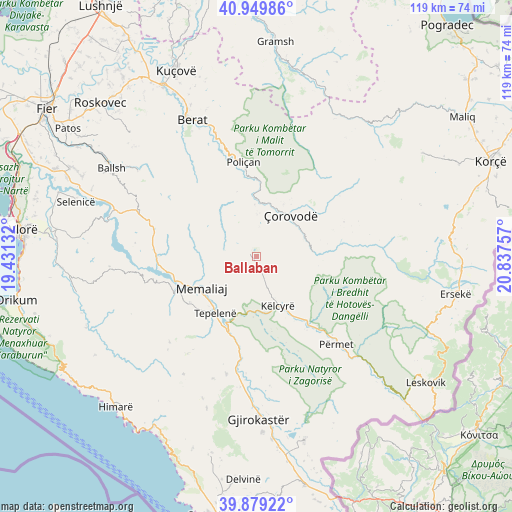
Ballaban GPS coordinates[2]
40° 25' 0.012" North, 20° 8' 3.984" East
| Map corner | latitude | longitude |
|---|---|---|
| Upper-left | 40.94986°, | 19.43132° |
| Center: | 40.41667°, | 20.13444° |
| Lower-right: | 39.87922°, | 20.83757° |
| Map W x H: | 119×119 km | = 73.9×73.9mi |
| max Lat: | 42.45139° ⇑87.3% North |
| Ballaban: | 40.41667° |
| min Lat: | ⇓12.7% South 39.65889° |
| min Long | Ballaban | max Long |
| 19.40556° | 20.13444° | 20.99° |
| W 63.1%⇐ | ⇒36.9% E |
Elevation
Elevation of Ballaban is 322 m = 1056 ft, and this is 52.6 m = 173 ft below average elevation for this country.
| Max E: |
1352 m = 4436 ft | 45.6% |
| Avg. | 374.6 m = 1229 ft | |
| Ballaban | 322 m = 1056 ft | |
Min E: |
-2 m = -7 ft | 54.4% |
See also: Albania elevation on elevation.city.
Geographical zone
Ballaban is located in North temperate zone (between Tropic of Cancer and the Arctic Circle). Distance of this Northern Tropic circle is 1888 km =1173.1 mi to South.| Distance of | km | miles | from Ballaban |
|---|---|---|---|
| North Pole | 5513.1 | 3425.7 | to North |
| Arctic Circle | 2907.3 | 1806.5 | to North |
| Tropic Cancer | 1888 | 1173.1 | to South |
| Equator | 4493.9 | 2792.4 | to South |


Nearby cities:
15 places around Ballaban: (largest is in red/bold)
• Bogovë
17.2 km =10.7 mi,  4°
4°
• Buz
11.4 km =7.1 mi,  286°
286°
• Këlcyrë
12.4 km =7.7 mi,  157°
157°
• Leshnjë
20.2 km =12.6 mi,  48°
48°
• Luftinjë
15.5 km =9.6 mi,  280°
280°
• Memaliaj
14.9 km =9.3 mi,  241°
241°
• Piskovë
19.3 km =12 mi,  142°
142°
• Poliçan
22 km =13.7 mi,  351°
351°
• Potom
21.7 km =13.5 mi,  68°
68°
• Sukë
4.9 km =3 mi, 159°
• Tepelenë
16.6 km =10.3 mi,  216°
216°
• Topojan
8 km =5 mi,  123°
123°
• Vendresha e Vogël
10.1 km =6.3 mi, 0°
• Çepan
10.7 km =6.6 mi,  87°
87°
• Çorovodë
12.5 km =7.8 mi,  38°
38°
Sources, notices
• [Note1] Compared only with cities in Albania existing in our database
• [Src1] Map data: © OpenStreetMap contributors (CC-BY-SA)
• [Src2] Other city data from geonames.org with taken over terms of usage.
• [Src3] Geographical zone / Annual Mean Temperature by Robert A. Rohde @ Wikipedia
