Bogovë geodata
Bogovë (Berat) is a seat of a third-order administrative division; located in Albania in Europe/Tirane (GMT+2) time zone. In our database, there are 71 cities with bigger population. Compared to other cities in Albania, 80.8% of cities are located further ↑North; 64.8% of cities are located further ←West and 58% of cities have higher elevation than Bogovë. Note1


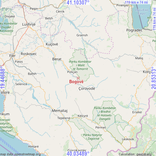
Bogovë GPS coordinates[2]
40° 34' 15.996" North, 20° 9' 0" East
| Map corner | latitude | longitude |
|---|---|---|
| Upper-left | 41.10307°, | 19.44688° |
| Center: | 40.57111°, | 20.15° |
| Lower-right: | 40.03489°, | 20.85313° |
| Map W x H: | 118.8×118.8 km | = 73.8×73.8mi |
| max Lat: | 42.45139° ⇑80.8% North |
| Bogovë: | 40.57111° |
| min Lat: | ⇓19.2% South 39.65889° |
| min Long | Bogovë | max Long |
| 19.40556° | 20.15° | 20.99° |
| W 64.8%⇐ | ⇒35.2% E |
Elevation
Elevation of Bogovë is 197 m = 646 ft, and this is 177.6 m = 583 ft below average elevation for this country.
| Max E: |
1352 m = 4436 ft | 58% |
| Avg. | 374.6 m = 1229 ft | |
| Bogovë | 197 m = 646 ft | |
Min E: |
-2 m = -7 ft | 42% |
See also: Albania elevation on elevation.city.
Geographical zone
Bogovë is located in North temperate zone (between Tropic of Cancer and the Arctic Circle). Distance of this Northern Tropic circle is 1905.2 km =1183.8 mi to South.| Distance of | km | miles | from Bogovë |
|---|---|---|---|
| North Pole | 5496 | 3415.1 | to North |
| Arctic Circle | 2890.1 | 1795.8 | to North |
| Tropic Cancer | 1905.2 | 1183.8 | to South |
| Equator | 4511.1 | 2803.1 | to South |


Nearby cities:
15 places around Bogovë: (largest is in red/bold)
• Ballaban
17.2 km =10.7 mi,  184°
184°
• Buz
18.6 km =11.6 mi,  221°
221°
• Gjerbës
10.7 km =6.6 mi,  52°
52°
• Leshnjë
14.3 km =8.9 mi,  105°
105°
• Luftinjë
21.8 km =13.5 mi,  229°
229°
• Poliçan
6.3 km =3.9 mi,  316°
316°
• Potom
21 km =13 mi,  115°
115°
• Roshnik
20.3 km =12.6 mi,  332°
332°
• Sukë
21.8 km =13.5 mi, 178°
• Topojan
22.2 km =13.8 mi,  166°
166°
• Vendresha e Vogël
7.2 km =4.5 mi,  190°
190°
• Vërtop
10.3 km =6.4 mi,  308°
308°
• Zhepë
16.6 km =10.3 mi,  44°
44°
• Çepan
19.2 km =11.9 mi,  150°
150°
• Çorovodë
9.9 km =6.2 mi,  138°
138°
Sources, notices
• [Note1] Compared only with cities in Albania existing in our database
• [Src1] Map data: © OpenStreetMap contributors (CC-BY-SA)
• [Src2] Other city data from geonames.org with taken over terms of usage.
• [Src3] Geographical zone / Annual Mean Temperature by Robert A. Rohde @ Wikipedia
