Gjerbës geodata
Gjerbës (Berat) is a seat of a third-order administrative division; located in Albania in Europe/Tirane (GMT+2) time zone. In our database, there are 71 cities with bigger population. Compared to other cities in Albania, 76.3% of cities are located further ↑North; 72.1% of cities are located further ←West and 86.2% of cities have lower elevation than Gjerbës. Note1


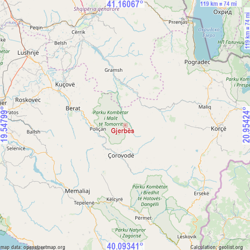
Gjerbës GPS coordinates[2]
40° 37' 45.012" North, 20° 15' 3.996" East
| Map corner | latitude | longitude |
|---|---|---|
| Upper-left | 41.16067°, | 19.54799° |
| Center: | 40.62917°, | 20.25111° |
| Lower-right: | 40.09341°, | 20.95424° |
| Map W x H: | 118.7×118.7 km | = 73.8×73.8mi |
| max Lat: | 42.45139° ⇑76.3% North |
| Gjerbës: | 40.62917° |
| min Lat: | ⇓23.7% South 39.65889° |
| min Long | Gjerbës | max Long |
| 19.40556° | 20.25111° | 20.99° |
| W 72.1%⇐ | ⇒27.9% E |
Elevation
Elevation of Gjerbës is 821 m = 2694 ft, and this is 446.4 m = 1465 ft above average elevation for this country.
| Max E: |
1352 m = 4436 ft | 13.8% |
| Gjerbës | 821 m 2694 ft | |
| Avg. | 374.6 m = 1229 ft | |
Min E: |
-2 m = -7 ft | 86.2% |
See also: Albania elevation on elevation.city.
Geographical zone
Gjerbës is located in North temperate zone (between Tropic of Cancer and the Arctic Circle). Distance of this Northern Tropic circle is 1911.6 km =1187.8 mi to South.| Distance of | km | miles | from Gjerbës |
|---|---|---|---|
| North Pole | 5489.5 | 3411 | to North |
| Arctic Circle | 2883.6 | 1791.8 | to North |
| Tropic Cancer | 1911.6 | 1187.8 | to South |
| Equator | 4517.5 | 2807 | to South |


Nearby cities:
15 places around Gjerbës: (largest is in red/bold)
• Bogovë
10.7 km =6.6 mi,  232°
232°
• Kodovjat
19.6 km =12.2 mi,  0°
0°
• Kushovë
18.5 km =11.5 mi,  343°
343°
• Lekas
22.3 km =13.9 mi,  97°
97°
• Lenias
19.3 km =12 mi,  37°
37°
• Leshnjë
11.5 km =7.1 mi,  152°
152°
• Moglicë
18.6 km =11.6 mi,  57°
57°
• Poliçan
13.1 km =8.1 mi,  261°
261°
• Potom
18.8 km =11.7 mi, 146°
• Roshnik
21.2 km =13.2 mi,  302°
302°
• Skënderbegas
16.4 km =10.2 mi,  356°
356°
• Vendresha e Vogël
16.7 km =10.4 mi,  215°
215°
• Vërtop
16.6 km =10.3 mi,  269°
269°
• Zhepë
6.2 km =3.9 mi,  29°
29°
• Çorovodë
14 km =8.7 mi,  188°
188°
Sources, notices
• [Note1] Compared only with cities in Albania existing in our database
• [Src1] Map data: © OpenStreetMap contributors (CC-BY-SA)
• [Src2] Other city data from geonames.org with taken over terms of usage.
• [Src3] Geographical zone / Annual Mean Temperature by Robert A. Rohde @ Wikipedia
