Trebinjë geodata
Trebinjë (Korçë) is a seat of a third-order administrative division; located in Albania in Europe/Tirane (GMT+2) time zone. In our database, there are 71 cities with bigger population. Compared to other cities in Albania, 58% of cities are located further ↑North; 91.5% of cities are located further ←West and 90.7% of cities have lower elevation than Trebinjë. Note1


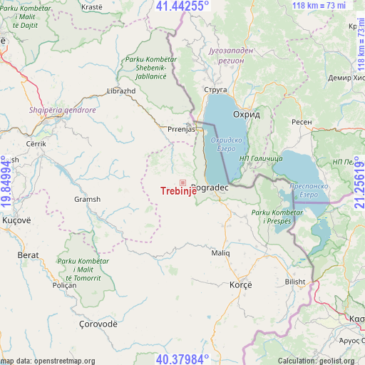
Trebinjë GPS coordinates[2]
40° 54' 47.988" North, 20° 33' 11.016" East
| Map corner | latitude | longitude |
|---|---|---|
| Upper-left | 41.44255°, | 19.84994° |
| Center: | 40.91333°, | 20.55306° |
| Lower-right: | 40.37984°, | 21.25619° |
| Map W x H: | 118.2×118.2 km | = 73.4×73.4mi |
| max Lat: | 42.45139° ⇑58% North |
| Trebinjë: | 40.91333° |
| min Lat: | ⇓42% South 39.65889° |
| min Long | Trebinjë | max Long |
| 19.40556° | 20.55306° | 20.99° |
| W 91.5%⇐ | ⇒8.5% E |
Elevation
Elevation of Trebinjë is 898 m = 2946 ft, and this is 523.4 m = 1717 ft above average elevation for this country.
| Max E: |
1352 m = 4436 ft | 9.3% |
| Trebinjë | 898 m 2946 ft | |
| Avg. | 374.6 m = 1229 ft | |
Min E: |
-2 m = -7 ft | 90.7% |
See also: Albania elevation on elevation.city.
Geographical zone
Trebinjë is located in North temperate zone (between Tropic of Cancer and the Arctic Circle). Distance of this Northern Tropic circle is 1943.2 km =1207.4 mi to South.| Distance of | km | miles | from Trebinjë |
|---|---|---|---|
| North Pole | 5457.9 | 3391.4 | to North |
| Arctic Circle | 2852 | 1772.2 | to North |
| Tropic Cancer | 1943.2 | 1207.4 | to South |
| Equator | 4549.1 | 2826.7 | to South |


Nearby cities:
15 places around Trebinjë: (largest is in red/bold)
• Buçimas
11.1 km =6.9 mi,  102°
102°
• Cerava
16 km =9.9 mi,  115°
115°
• Dardhas
11.5 km =7.1 mi,  130°
130°
• Kukur
16.7 km =10.4 mi,  252°
252°
• Lenias
21.2 km =13.2 mi,  219°
219°
• Novoselë
20.9 km =13 mi,  144°
144°
• Pirg
19.2 km =11.9 mi, 137°
• Pogradec
8.4 km =5.2 mi, 98°
• Proptisht
9.1 km =5.7 mi,  332°
332°
• Përrenjas
17.8 km =11.1 mi,  358°
358°
• Përrenjas-Fshat
17.1 km =10.6 mi,  354°
354°
• Rajcë
19.8 km =12.3 mi,  5°
5°
• Stravaj
15 km =9.3 mi,  313°
313°
• Udënisht
9.1 km =5.7 mi,  52°
52°
• Velçan
8.9 km =5.5 mi,  301°
301°
Sources, notices
• [Note1] Compared only with cities in Albania existing in our database
• [Src1] Map data: © OpenStreetMap contributors (CC-BY-SA)
• [Src2] Other city data from geonames.org with taken over terms of usage.
• [Src3] Geographical zone / Annual Mean Temperature by Robert A. Rohde @ Wikipedia
