Udënisht geodata
Udënisht (Korçë) is a seat of a third-order administrative division; located in Albania in Europe/Tirane (GMT+2) time zone. In our database, there are 71 cities with bigger population. Compared to other cities in Albania, 54.9% of cities are located further ↑North; 93.5% of cities are located further ←West and 78.6% of cities have lower elevation than Udënisht. Note1


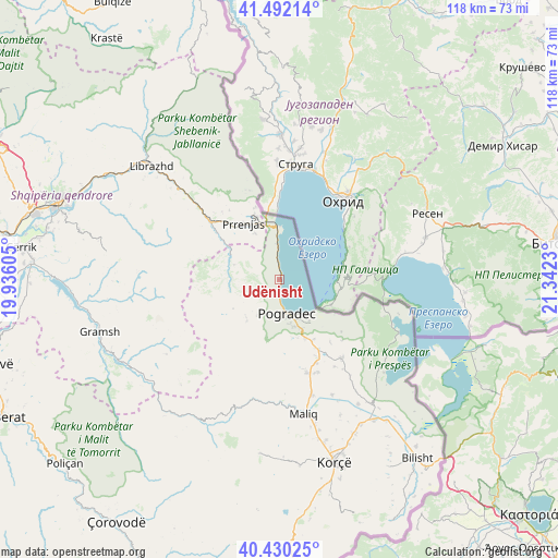
Udënisht GPS coordinates[2]
40° 57' 47.988" North, 20° 38' 21.012" East
| Map corner | latitude | longitude |
|---|---|---|
| Upper-left | 41.49214°, | 19.93605° |
| Center: | 40.96333°, | 20.63917° |
| Lower-right: | 40.43025°, | 21.3423° |
| Map W x H: | 118.1×118.1 km | = 73.4×73.4mi |
| max Lat: | 42.45139° ⇑54.9% North |
| Udënisht: | 40.96333° |
| min Lat: | ⇓45.1% South 39.65889° |
| min Long | Udënisht | max Long |
| 19.40556° | 20.63917° | 20.99° |
| W 93.5%⇐ | ⇒6.5% E |
Elevation
Elevation of Udënisht is 743 m = 2438 ft, and this is 368.4 m = 1209 ft above average elevation for this country.
| Max E: |
1352 m = 4436 ft | 21.4% |
| Udënisht | 743 m 2438 ft | |
| Avg. | 374.6 m = 1229 ft | |
Min E: |
-2 m = -7 ft | 78.6% |
See also: Albania elevation on elevation.city.
Geographical zone
Udënisht is located in North temperate zone (between Tropic of Cancer and the Arctic Circle). Distance of this Northern Tropic circle is 1948.8 km =1210.9 mi to South.| Distance of | km | miles | from Udënisht |
|---|---|---|---|
| North Pole | 5452.4 | 3388 | to North |
| Arctic Circle | 2846.5 | 1768.7 | to North |
| Tropic Cancer | 1948.8 | 1210.9 | to South |
| Equator | 4554.7 | 2830.2 | to South |


Nearby cities:
15 places around Udënisht: (largest is in red/bold)
• Buçimas
8.8 km =5.5 mi,  156°
156°
• Cerava
14.4 km =8.9 mi,  149°
149°
• Dardhas
13.2 km =8.2 mi,  173°
173°
• Pirg
20.6 km =12.8 mi, 164°
• Pogradec
6.9 km =4.3 mi, 170°
• Proptisht
11.7 km =7.3 mi,  282°
282°
• Përrenjas
14.4 km =8.9 mi,  328°
328°
• Përrenjas-Fshat
14.4 km =8.9 mi,  322°
322°
• Qukës-Shkumbin
21.6 km =13.4 mi,  311°
311°
• Qukës-Skënderbe
21.5 km =13.4 mi, 308°
• Rajcë
15.1 km =9.4 mi,  339°
339°
• Stravaj
18.7 km =11.6 mi, 284°
• Trebinjë
9.1 km =5.7 mi,  232°
232°
• Velçan
14.9 km =9.3 mi,  266°
266°
• Vreshtas
21.8 km =13.5 mi, 147°
Sources, notices
• [Note1] Compared only with cities in Albania existing in our database
• [Src1] Map data: © OpenStreetMap contributors (CC-BY-SA)
• [Src2] Other city data from geonames.org with taken over terms of usage.
• [Src3] Geographical zone / Annual Mean Temperature by Robert A. Rohde @ Wikipedia
