Brrnakot’ geodata
Brrnakot’ (Syunik) is a populated place; located in Armenia in Asia/Yerevan (GMT+4) time zone. With population of 1,912 people, there are 167 cities with bigger population in this country. Compared to other cities in Armenia, 97.8% of cities are located further ↑North; 96.5% of cities are located further ←West and 76.1% of cities have lower elevation than Brrnakot’. Note1


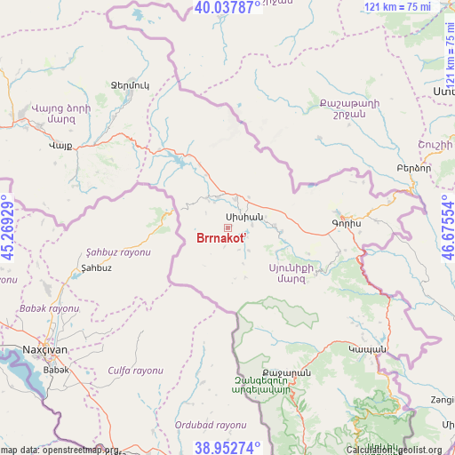
Brrnakot’ GPS coordinates[2]
39° 29' 50.712" North, 45° 58' 20.676" East
| Map corner | latitude | longitude |
|---|---|---|
| Upper-left | 40.03787°, | 45.26929° |
| Center: | 39.49742°, | 45.97241° |
| Lower-right: | 38.95274°, | 46.67554° |
| Map W x H: | 120.7×120.7 km | = 75×75mi |
| max Lat: | 41.24358° ⇑97.8% North |
| Brrnakot’: | 39.49742° |
| min Lat: | ⇓2.2% South 38.90292° |
| min Long | Brrnakot’ | max Long |
| 43.74722° | 45.97241° | 46.5446° |
| W 96.5%⇐ | ⇒3.5% E |
Elevation
Elevation of Brrnakot’ is 1698 m = 5571 ft, and this is 396.5 m = 1301 ft above average elevation for this country.
| Max E: |
2169 m = 7116 ft | 23.9% |
| Brrnakot’ | 1698 m 5571 ft | |
| Avg. | 1301.5 m = 4270 ft | |
Min E: |
440 m = 1444 ft | 76.1% |
See also: Armenia elevation on elevation.city.
Geographical zone
Brrnakot’ is located in North temperate zone (between Tropic of Cancer and the Arctic Circle). Distance of this Northern Tropic circle is 1785.8 km =1109.6 mi to South.| Distance of | km | miles | from Brrnakot’ |
|---|---|---|---|
| North Pole | 5615.4 | 3489.2 | to North |
| Arctic Circle | 3009.5 | 1870 | to North |
| Tropic Cancer | 1785.8 | 1109.6 | to South |
| Equator | 4391.7 | 2728.9 | to South |


Nearby cities:
15 places around Brrnakot’: (largest is in red/bold)
• Akner
29 km =18 mi,  81°
81°
• Angeghakot’
8.4 km =5.2 mi,  343°
343°
• Dzorastan
41.6 km =25.8 mi,  127°
127°
• Gorayk’
27.3 km =17 mi,  318°
318°
• Goris
31.7 km =19.7 mi,  87°
87°
• Hats’avan
3.7 km =2.3 mi,  182°
182°
• Jermuk
46.2 km =28.7 mi,  325°
325°
• Khndzoresk
39.8 km =24.7 mi, 88°
• Shaghat
8.7 km =5.4 mi, 319°
• Shinuhayr
30.4 km =18.9 mi,  102°
102°
• Tat’ev
26.4 km =16.4 mi,  117°
117°
• Tegh
44.1 km =27.4 mi, 81°
• Vayk’
48.3 km =30 mi,  296°
296°
• Verishen
30.2 km =18.8 mi, 81°
• Zarrit’ap’
42.6 km =26.5 mi,  291°
291°
Sources, notices
• [Note1] Compared only with cities in Armenia existing in our database
• [Src1] Map data: © OpenStreetMap contributors (CC-BY-SA)
• [Src2] Other city data from geonames.org with taken over terms of usage.
• [Src3] Geographical zone / Annual Mean Temperature by Robert A. Rohde @ Wikipedia
