Aygezard geodata
Aygezard (Ararat) is a populated place; located in Armenia in Asia/Yerevan (GMT+4) time zone. With population of 3,192 people, there are 86 cities with bigger population in this country. Compared to other cities in Armenia, 85.7% of cities are located further ↑North; 58% of cities are located further ←West and 70.7% of cities have higher elevation than Aygezard. Note1


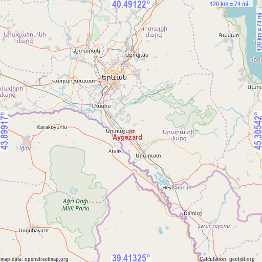
Aygezard GPS coordinates[2]
39° 57' 15.696" North, 44° 36' 8.244" East
| Map corner | latitude | longitude |
|---|---|---|
| Upper-left | 40.49122°, | 43.89917° |
| Center: | 39.95436°, | 44.60229° |
| Lower-right: | 39.41325°, | 45.30542° |
| Map W x H: | 119.9×119.9 km | = 74.5×74.5mi |
| max Lat: | 41.24358° ⇑85.7% North |
| Aygezard: | 39.95436° |
| min Lat: | ⇓14.3% South 38.90292° |
| min Long | Aygezard | max Long |
| 43.74722° | 44.60229° | 46.5446° |
| W 58%⇐ | ⇒42% E |
Elevation
Elevation of Aygezard is 877 m = 2877 ft, and this is 424.5 m = 1393 ft below average elevation for this country.
| Max E: |
2169 m = 7116 ft | 70.7% |
| Avg. | 1301.5 m = 4270 ft | |
| Aygezard | 877 m = 2877 ft | |
Min E: |
440 m = 1444 ft | 29.3% |
See also: Armenia elevation on elevation.city.
Geographical zone
Aygezard is located in North temperate zone (between Tropic of Cancer and the Arctic Circle). Distance of this Northern Tropic circle is 1836.6 km =1141.2 mi to South.| Distance of | km | miles | from Aygezard |
|---|---|---|---|
| North Pole | 5564.6 | 3457.7 | to North |
| Arctic Circle | 2958.7 | 1838.5 | to North |
| Tropic Cancer | 1836.6 | 1141.2 | to South |
| Equator | 4442.5 | 2760.4 | to South |


Nearby cities:
15 places around Aygezard: (largest is in red/bold)
• Aralez
7.6 km =4.7 mi,  142°
142°
• Artashat
5 km =3.1 mi,  279°
279°
• Aygepat
0.5 km =0.3 mi,  335°
335°
• Aygestan
6.6 km =4.1 mi,  325°
325°
• Berk’anush
7.7 km =4.8 mi,  289°
289°
• Dalar
6.9 km =4.3 mi, 290°
• Dvin
7.4 km =4.6 mi,  347°
347°
• Lusarrat
9 km =5.6 mi,  188°
188°
• Mrgavan
6 km =3.7 mi, 289°
• Norashen
5.3 km =3.3 mi, 351°
• Shahumyan
2.9 km =1.8 mi,  241°
241°
• Sisavan
7.6 km =4.7 mi,  132°
132°
• Verin Artashat
4.9 km =3 mi, 346°
• Verin Dvin
7.8 km =4.8 mi, 352°
• Vostan
3.8 km =2.4 mi, 288°
Sources, notices
• [Note1] Compared only with cities in Armenia existing in our database
• [Src1] Map data: © OpenStreetMap contributors (CC-BY-SA)
• [Src2] Other city data from geonames.org with taken over terms of usage.
• [Src3] Geographical zone / Annual Mean Temperature by Robert A. Rohde @ Wikipedia
