Voskehask geodata
Voskehask (Shirak) is a populated place; located in Armenia in Asia/Yerevan (GMT+4) time zone. With population of 1,803 people, there are 181 cities with bigger population in this country. Compared to other cities in Armenia, 81.2% of cities are located further ↓South; 99% of cities are located further →East and 62.7% of cities have lower elevation than Voskehask. Note1


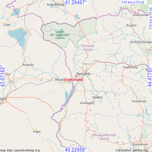
Voskehask GPS coordinates[2]
40° 45' 51.336" North, 43° 46' 29.064" East
| Map corner | latitude | longitude |
|---|---|---|
| Upper-left | 41.29467°, | 43.07162° |
| Center: | 40.76426°, | 43.77474° |
| Lower-right: | 40.22958°, | 44.47787° |
| Map W x H: | 118.4×118.4 km | = 73.6×73.6mi |
| max Lat: | 41.24358° ⇑18.8% North |
| Voskehask: | 40.76426° |
| min Lat: | ⇓81.2% South 38.90292° |
| min Long | Voskehask | max Long |
| 43.74722° | 43.77474° | 46.5446° |
| W 1%⇐ | ⇒99% E |
Elevation
Elevation of Voskehask is 1495 m = 4905 ft, and this is 193.5 m = 635 ft above average elevation for this country.
| Max E: |
2169 m = 7116 ft | 37.3% |
| Voskehask | 1495 m 4905 ft | |
| Avg. | 1301.5 m = 4270 ft | |
Min E: |
440 m = 1444 ft | 62.7% |
See also: Armenia elevation on elevation.city.
Geographical zone
Voskehask is located in North temperate zone (between Tropic of Cancer and the Arctic Circle). Distance of this Northern Tropic circle is 1926.6 km =1197.1 mi to South.| Distance of | km | miles | from Voskehask |
|---|---|---|---|
| North Pole | 5474.5 | 3401.7 | to North |
| Arctic Circle | 2868.6 | 1782.5 | to North |
| Tropic Cancer | 1926.6 | 1197.1 | to South |
| Equator | 4532.6 | 2816.4 | to South |


Nearby cities:
15 places around Voskehask: (largest is in red/bold)
• Akhuryan
10.7 km =6.6 mi,  80°
80°
• Arevik
11.2 km =7 mi,  102°
102°
• Arrap’i
3.3 km =2.1 mi,  51°
51°
• Azatan
6.7 km =4.2 mi,  138°
138°
• Basen
18.4 km =11.4 mi,  92°
92°
• Gyumri
6.8 km =4.2 mi,  60°
60°
• Haykavan
4.7 km =2.9 mi,  335°
335°
• Horrom
15.2 km =9.4 mi, 140°
• Kamo
16.3 km =10.1 mi,  65°
65°
• Marmashen
7.9 km =4.9 mi,  1°
1°
• Mayisyan
10.7 km =6.6 mi,  30°
30°
• Meghrashen
18.5 km =11.5 mi,  123°
123°
• Saratak
13.2 km =8.2 mi, 141°
• Shirak
14.6 km =9.1 mi, 54°
• Yerazgavors
8 km =5 mi,  196°
196°
Sources, notices
• [Note1] Compared only with cities in Armenia existing in our database
• [Src1] Map data: © OpenStreetMap contributors (CC-BY-SA)
• [Src2] Other city data from geonames.org with taken over terms of usage.
• [Src3] Geographical zone / Annual Mean Temperature by Robert A. Rohde @ Wikipedia
