Akhuryan geodata
Akhuryan (Shirak) is a populated place; located in Armenia in Asia/Yerevan (GMT+4) time zone. With population of 7,672 people, there are 29 cities with bigger population in this country. Compared to other cities in Armenia, 82.5% of cities are located further ↓South; 94.9% of cities are located further →East and 66.2% of cities have lower elevation than Akhuryan. Note1


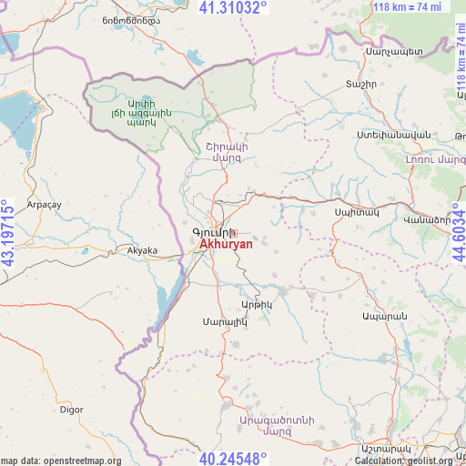
Akhuryan GPS coordinates[2]
40° 46' 48.108" North, 43° 54' 0.972" East
| Map corner | latitude | longitude |
|---|---|---|
| Upper-left | 41.31032°, | 43.19715° |
| Center: | 40.78003°, | 43.90027° |
| Lower-right: | 40.24548°, | 44.6034° |
| Map W x H: | 118.4×118.4 km | = 73.6×73.6mi |
| max Lat: | 41.24358° ⇑17.5% North |
| Akhuryan: | 40.78003° |
| min Lat: | ⇓82.5% South 38.90292° |
| min Long | Akhuryan | max Long |
| 43.74722° | 43.90027° | 46.5446° |
| W 5.1%⇐ | ⇒94.9% E |
Elevation
Elevation of Akhuryan is 1544 m = 5066 ft, and this is 242.5 m = 796 ft above average elevation for this country.
| Max E: |
2169 m = 7116 ft | 33.8% |
| Akhuryan | 1544 m 5066 ft | |
| Avg. | 1301.5 m = 4270 ft | |
Min E: |
440 m = 1444 ft | 66.2% |
See also: Armenia elevation on elevation.city.
Geographical zone
Akhuryan is located in North temperate zone (between Tropic of Cancer and the Arctic Circle). Distance of this Northern Tropic circle is 1928.4 km =1198.3 mi to South.| Distance of | km | miles | from Akhuryan |
|---|---|---|---|
| North Pole | 5472.7 | 3400.6 | to North |
| Arctic Circle | 2866.9 | 1781.4 | to North |
| Tropic Cancer | 1928.4 | 1198.3 | to South |
| Equator | 4534.3 | 2817.5 | to South |


Nearby cities:
15 places around Akhuryan: (largest is in red/bold)
• Anushavan
16 km =9.9 mi,  154°
154°
• Arevik
4.3 km =2.7 mi,  175°
175°
• Arrap’i
8 km =5 mi,  272°
272°
• Azatan
9.1 km =5.7 mi,  222°
222°
• Basen
8.2 km =5.1 mi,  107°
107°
• Gyumri
4.9 km =3 mi,  288°
288°
• Haykavan
12.8 km =8 mi,  281°
281°
• Horrom
13.4 km =8.3 mi, 183°
• Kamo
6.6 km =4.1 mi,  39°
39°
• Marmashen
12 km =7.5 mi,  300°
300°
• Mayisyan
9.1 km =5.7 mi,  325°
325°
• Meghrashen
12.9 km =8 mi,  157°
157°
• Saratak
12.4 km =7.7 mi,  190°
190°
• Shirak
6.8 km =4.2 mi,  11°
11°
• Voskehask
10.7 km =6.6 mi,  260°
260°
Sources, notices
• [Note1] Compared only with cities in Armenia existing in our database
• [Src1] Map data: © OpenStreetMap contributors (CC-BY-SA)
• [Src2] Other city data from geonames.org with taken over terms of usage.
• [Src3] Geographical zone / Annual Mean Temperature by Robert A. Rohde @ Wikipedia
