Noramarg geodata
Noramarg (Ararat) is a populated place; located in Armenia in Asia/Yerevan (GMT+4) time zone. With population of 1,811 people, there are 180 cities with bigger population in this country. Compared to other cities in Armenia, 81.2% of cities are located further ↑North; 58.6% of cities are located further →East and 93.3% of cities have higher elevation than Noramarg. Note1


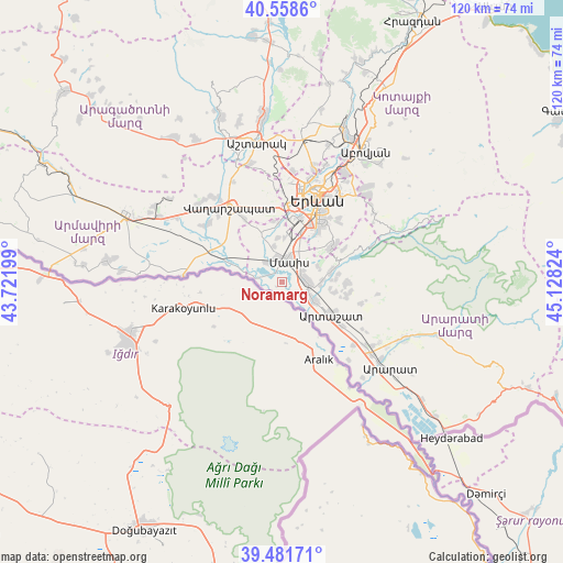
Noramarg GPS coordinates[2]
40° 1' 20.208" North, 44° 25' 30.396" East
| Map corner | latitude | longitude |
|---|---|---|
| Upper-left | 40.5586°, | 43.72199° |
| Center: | 40.02228°, | 44.42511° |
| Lower-right: | 39.48171°, | 45.12824° |
| Map W x H: | 119.7×119.7 km | = 74.4×74.4mi |
| max Lat: | 41.24358° ⇑81.2% North |
| Noramarg: | 40.02228° |
| min Lat: | ⇓18.8% South 38.90292° |
| min Long | Noramarg | max Long |
| 43.74722° | 44.42511° | 46.5446° |
| W 41.4%⇐ | ⇒58.6% E |
Elevation
Elevation of Noramarg is 829 m = 2720 ft, and this is 472.5 m = 1550 ft below average elevation for this country.
| Max E: |
2169 m = 7116 ft | 93.3% |
| Avg. | 1301.5 m = 4270 ft | |
| Noramarg | 829 m = 2720 ft | |
Min E: |
440 m = 1444 ft | 6.7% |
See also: Armenia elevation on elevation.city.
Geographical zone
Noramarg is located in North temperate zone (between Tropic of Cancer and the Arctic Circle). Distance of this Northern Tropic circle is 1844.1 km =1145.9 mi to South.| Distance of | km | miles | from Noramarg |
|---|---|---|---|
| North Pole | 5557 | 3453 | to North |
| Arctic Circle | 2951.1 | 1833.7 | to North |
| Tropic Cancer | 1844.1 | 1145.9 | to South |
| Equator | 4450.1 | 2765.2 | to South |


Nearby cities:
15 places around Noramarg: (largest is in red/bold)
• Arevabuyr
4.1 km =2.5 mi,  67°
67°
• Burastan
7 km =4.3 mi,  119°
119°
• Byuravan
8 km =5 mi,  94°
94°
• Dimitrov
5.9 km =3.7 mi,  105°
105°
• Hovtashen
2.1 km =1.3 mi,  81°
81°
• Jrahovit
5.1 km =3.2 mi,  56°
56°
• Jrashen
8.2 km =5.1 mi, 65°
• Marmarashen
5.7 km =3.5 mi,  45°
45°
• Masis
4.9 km =3 mi,  350°
350°
• Mrgavet
5 km =3.1 mi, 82°
• Nizami
7.9 km =4.9 mi, 347°
• Rranch’par
4.8 km =3 mi,  277°
277°
• Sayat’-Nova
6.2 km =3.9 mi,  340°
340°
• Sis
5.1 km =3.2 mi,  322°
322°
• Zorak
8.1 km =5 mi, 341°
Sources, notices
• [Note1] Compared only with cities in Armenia existing in our database
• [Src1] Map data: © OpenStreetMap contributors (CC-BY-SA)
• [Src2] Other city data from geonames.org with taken over terms of usage.
• [Src3] Geographical zone / Annual Mean Temperature by Robert A. Rohde @ Wikipedia
