Masis geodata
Masis (Ararat) is a populated place; located in Armenia in Asia/Yerevan (GMT+4) time zone. With population of 18,911 people, there are 13 cities with bigger population in this country. Compared to other cities in Armenia, 73.6% of cities are located further ↑North; 59.9% of cities are located further →East and 91.7% of cities have higher elevation than Masis. Note1


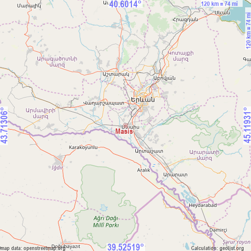
Masis GPS coordinates[2]
40° 3' 55.512" North, 44° 24' 58.248" East
| Map corner | latitude | longitude |
|---|---|---|
| Upper-left | 40.6014°, | 43.71306° |
| Center: | 40.06542°, | 44.41618° |
| Lower-right: | 39.52519°, | 45.11931° |
| Map W x H: | 119.7×119.7 km | = 74.4×74.4mi |
| max Lat: | 41.24358° ⇑73.6% North |
| Masis: | 40.06542° |
| min Lat: | ⇓26.4% South 38.90292° |
| min Long | Masis | max Long |
| 43.74722° | 44.41618° | 46.5446° |
| W 40.1%⇐ | ⇒59.9% E |
Elevation
Elevation of Masis is 833 m = 2733 ft, and this is 468.5 m = 1537 ft below average elevation for this country.
| Max E: |
2169 m = 7116 ft | 91.7% |
| Avg. | 1301.5 m = 4270 ft | |
| Masis | 833 m = 2733 ft | |
Min E: |
440 m = 1444 ft | 8.3% |
See also: Armenia elevation on elevation.city.
Geographical zone
Masis is located in North temperate zone (between Tropic of Cancer and the Arctic Circle). Distance of this Northern Tropic circle is 1848.9 km =1148.9 mi to South.| Distance of | km | miles | from Masis |
|---|---|---|---|
| North Pole | 5552.2 | 3450 | to North |
| Arctic Circle | 2946.3 | 1830.7 | to North |
| Tropic Cancer | 1848.9 | 1148.9 | to South |
| Equator | 4454.9 | 2768.1 | to South |


Nearby cities:
15 places around Masis: (largest is in red/bold)
• Arevabuyr
5.6 km =3.5 mi,  125°
125°
• Darakert
4.5 km =2.8 mi,  357°
357°
• Dashtavan
4.4 km =2.7 mi,  331°
331°
• Ghukasavan
7 km =4.3 mi,  0°
0°
• Hovtashen
5.3 km =3.3 mi,  147°
147°
• Jrahovit
5.4 km =3.4 mi,  111°
111°
• Marmarashen
4.8 km =3 mi,  99°
99°
• Mrgavet
7.1 km =4.4 mi, 126°
• Nizami
3.1 km =1.9 mi,  343°
343°
• Norabats’
4.7 km =2.9 mi,  18°
18°
• Noramarg
4.9 km =3 mi,  170°
170°
• Rranch’par
5.8 km =3.6 mi,  223°
223°
• Sayat’-Nova
1.7 km =1.1 mi,  308°
308°
• Sis
2.5 km =1.6 mi,  251°
251°
• Zorak
3.5 km =2.2 mi, 327°
Sources, notices
• [Note1] Compared only with cities in Armenia existing in our database
• [Src1] Map data: © OpenStreetMap contributors (CC-BY-SA)
• [Src2] Other city data from geonames.org with taken over terms of usage.
• [Src3] Geographical zone / Annual Mean Temperature by Robert A. Rohde @ Wikipedia
