Jrahovit geodata
Jrahovit (Ararat) is a populated place; located in Armenia in Asia/Yerevan (GMT+4) time zone. With population of 1,032 people, there are 299 cities with bigger population in this country. Compared to other cities in Armenia, 76.4% of cities are located further ↑North; 55.1% of cities are located further →East and 89.2% of cities have higher elevation than Jrahovit. Note1


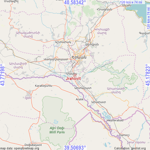
Jrahovit GPS coordinates[2]
40° 2' 50.28" North, 44° 28' 30.36" East
| Map corner | latitude | longitude |
|---|---|---|
| Upper-left | 40.58342°, | 43.77198° |
| Center: | 40.0473°, | 44.4751° |
| Lower-right: | 39.50693°, | 45.17823° |
| Map W x H: | 119.7×119.7 km | = 74.4×74.4mi |
| max Lat: | 41.24358° ⇑76.4% North |
| Jrahovit: | 40.0473° |
| min Lat: | ⇓23.6% South 38.90292° |
| min Long | Jrahovit | max Long |
| 43.74722° | 44.4751° | 46.5446° |
| W 44.9%⇐ | ⇒55.1% E |
Elevation
Elevation of Jrahovit is 837 m = 2746 ft, and this is 464.5 m = 1524 ft below average elevation for this country.
| Max E: |
2169 m = 7116 ft | 89.2% |
| Avg. | 1301.5 m = 4270 ft | |
| Jrahovit | 837 m = 2746 ft | |
Min E: |
440 m = 1444 ft | 10.8% |
See also: Armenia elevation on elevation.city.
Geographical zone
Jrahovit is located in North temperate zone (between Tropic of Cancer and the Arctic Circle). Distance of this Northern Tropic circle is 1846.9 km =1147.6 mi to South.| Distance of | km | miles | from Jrahovit |
|---|---|---|---|
| North Pole | 5554.2 | 3451.2 | to North |
| Arctic Circle | 2948.3 | 1832 | to North |
| Tropic Cancer | 1846.9 | 1147.6 | to South |
| Equator | 4452.8 | 2766.8 | to South |


Nearby cities:
15 places around Jrahovit: (largest is in red/bold)
• Abovyan
6.2 km =3.9 mi,  88°
88°
• Arevabuyr
1.3 km =0.8 mi,  200°
200°
• Arevshat
5.7 km =3.5 mi,  98°
98°
• Burastan
6.5 km =4 mi,  163°
163°
• Byuravan
5.1 km =3.2 mi,  132°
132°
• Dimitrov
4.5 km =2.8 mi, 161°
• Hovtashen
3.3 km =2.1 mi,  220°
220°
• Jrashen
3.2 km =2 mi,  79°
79°
• Marmarashen
1.2 km =0.7 mi,  348°
348°
• Masis
5.4 km =3.4 mi,  291°
291°
• Mrganush
7.4 km =4.6 mi,  106°
106°
• Mrgavet
2.3 km =1.4 mi, 162°
• Noramarg
5.1 km =3.2 mi,  236°
236°
• Nshavan
4.8 km =3 mi,  116°
116°
• Sayat’-Nova
7.1 km =4.4 mi,  295°
295°
Sources, notices
• [Note1] Compared only with cities in Armenia existing in our database
• [Src1] Map data: © OpenStreetMap contributors (CC-BY-SA)
• [Src2] Other city data from geonames.org with taken over terms of usage.
• [Src3] Geographical zone / Annual Mean Temperature by Robert A. Rohde @ Wikipedia
