Kaputan geodata
Kaputan (Kotayk) is a populated place; located in Armenia in Asia/Yerevan (GMT+4) time zone. With population of 1,252 people, there are 257 cities with bigger population in this country. Compared to other cities in Armenia, 60.8% of cities are located further ↓South; 66.6% of cities are located further ←West and 79% of cities have lower elevation than Kaputan. Note1


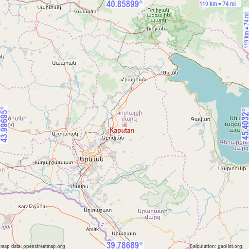
Kaputan GPS coordinates[2]
40° 19' 30.252" North, 44° 42' 0.252" East
| Map corner | latitude | longitude |
|---|---|---|
| Upper-left | 40.85899°, | 43.99695° |
| Center: | 40.32507°, | 44.70007° |
| Lower-right: | 39.78689°, | 45.4032° |
| Map W x H: | 119.2×119.2 km | = 74.1×74.1mi |
| max Lat: | 41.24358° ⇑39.2% North |
| Kaputan: | 40.32507° |
| min Lat: | ⇓60.8% South 38.90292° |
| min Long | Kaputan | max Long |
| 43.74722° | 44.70007° | 46.5446° |
| W 66.6%⇐ | ⇒33.4% E |
Elevation
Elevation of Kaputan is 1765 m = 5791 ft, and this is 463.5 m = 1521 ft above average elevation for this country.
| Max E: |
2169 m = 7116 ft | 21% |
| Kaputan | 1765 m 5791 ft | |
| Avg. | 1301.5 m = 4270 ft | |
Min E: |
440 m = 1444 ft | 79% |
See also: Armenia elevation on elevation.city.
Geographical zone
Kaputan is located in North temperate zone (between Tropic of Cancer and the Arctic Circle). Distance of this Northern Tropic circle is 1877.8 km =1166.8 mi to South.| Distance of | km | miles | from Kaputan |
|---|---|---|---|
| North Pole | 5523.3 | 3432 | to North |
| Arctic Circle | 2917.4 | 1812.8 | to North |
| Tropic Cancer | 1877.8 | 1166.8 | to South |
| Equator | 4483.7 | 2786 | to South |


Nearby cities:
15 places around Kaputan: (largest is in red/bold)
• Abovyan
8 km =5 mi,  224°
224°
• Akunk’
6.6 km =4.1 mi,  190°
190°
• Aramus
8.8 km =5.5 mi,  200°
200°
• Argel
10.3 km =6.4 mi,  304°
304°
• Arzni
9.1 km =5.7 mi,  250°
250°
• Balahovit
11.3 km =7 mi, 223°
• Byureghavan
9.1 km =5.7 mi,  262°
262°
• Fantan
7.8 km =4.8 mi,  351°
351°
• Kotayk’
6.1 km =3.8 mi,  210°
210°
• Mayakovski
9.6 km =6 mi, 212°
• Mrgashen
13.9 km =8.6 mi, 251°
• Nor Geghi
9.9 km =6.2 mi,  268°
268°
• Nor Gyugh
7.4 km =4.6 mi, 208°
• Ptghni
12.4 km =7.7 mi,  231°
231°
• Zarr
7.9 km =4.9 mi,  159°
159°
Sources, notices
• [Note1] Compared only with cities in Armenia existing in our database
• [Src1] Map data: © OpenStreetMap contributors (CC-BY-SA)
• [Src2] Other city data from geonames.org with taken over terms of usage.
• [Src3] Geographical zone / Annual Mean Temperature by Robert A. Rohde @ Wikipedia
