Byureghavan geodata
Byureghavan (Kotayk) is a populated place; located in Armenia in Asia/Yerevan (GMT+4) time zone. With population of 6,972 people, there are 32 cities with bigger population in this country. Compared to other cities in Armenia, 59.9% of cities are located further ↓South; 56.7% of cities are located further ←West and 55.1% of cities have lower elevation than Byureghavan. Note1


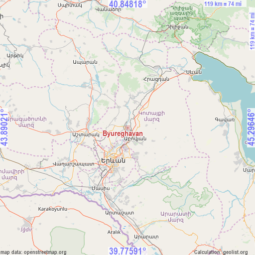
Byureghavan GPS coordinates[2]
40° 18' 51.012" North, 44° 35' 35.988" East
| Map corner | latitude | longitude |
|---|---|---|
| Upper-left | 40.84818°, | 43.89021° |
| Center: | 40.31417°, | 44.59333° |
| Lower-right: | 39.77591°, | 45.29646° |
| Map W x H: | 119.2×119.2 km | = 74.1×74.1mi |
| max Lat: | 41.24358° ⇑40.1% North |
| Byureghavan: | 40.31417° |
| min Lat: | ⇓59.9% South 38.90292° |
| min Long | Byureghavan | max Long |
| 43.74722° | 44.59333° | 46.5446° |
| W 56.7%⇐ | ⇒43.3% E |
Elevation
Elevation of Byureghavan is 1385 m = 4544 ft, and this is 83.5 m = 274 ft above average elevation for this country.
| Max E: |
2169 m = 7116 ft | 44.9% |
| Byureghavan | 1385 m 4544 ft | |
| Avg. | 1301.5 m = 4270 ft | |
Min E: |
440 m = 1444 ft | 55.1% |
See also: Armenia elevation on elevation.city.
Geographical zone
Byureghavan is located in North temperate zone (between Tropic of Cancer and the Arctic Circle). Distance of this Northern Tropic circle is 1876.6 km =1166.1 mi to South.| Distance of | km | miles | from Byureghavan |
|---|---|---|---|
| North Pole | 5524.5 | 3432.8 | to North |
| Arctic Circle | 2918.7 | 1813.6 | to North |
| Tropic Cancer | 1876.6 | 1166.1 | to South |
| Equator | 4482.5 | 2785.3 | to South |


Nearby cities:
15 places around Byureghavan: (largest is in red/bold)
• Abovyan
5.6 km =3.5 mi,  142°
142°
• Aramus
9.2 km =5.7 mi, 139°
• Argel
7.1 km =4.4 mi,  4°
4°
• Arzni
1.9 km =1.2 mi,  166°
166°
• Balahovit
7.1 km =4.4 mi, 169°
• Kaputan
9.1 km =5.7 mi,  82°
82°
• Kotayk’
7.2 km =4.5 mi,  123°
123°
• K’anak’erravan
8.9 km =5.5 mi,  213°
213°
• Mayakovski
7.8 km =4.8 mi,  150°
150°
• Mrgashen
5.2 km =3.2 mi,  232°
232°
• Nor Geghi
1.2 km =0.7 mi,  316°
316°
• Nor Gyugh
7.6 km =4.7 mi,  133°
133°
• Ptghni
6.5 km =4 mi,  185°
185°
• Yeghvard
9.2 km =5.7 mi,  277°
277°
• Zoravan
7.6 km =4.7 mi,  307°
307°
Sources, notices
• [Note1] Compared only with cities in Armenia existing in our database
• [Src1] Map data: © OpenStreetMap contributors (CC-BY-SA)
• [Src2] Other city data from geonames.org with taken over terms of usage.
• [Src3] Geographical zone / Annual Mean Temperature by Robert A. Rohde @ Wikipedia
