Dashtavan geodata
Dashtavan (Ararat) is a populated place; located in Armenia in Asia/Yerevan (GMT+4) time zone. With population of 1,762 people, there are 185 cities with bigger population in this country. Compared to other cities in Armenia, 68.2% of cities are located further ↑North; 63.1% of cities are located further →East and 90.1% of cities have higher elevation than Dashtavan. Note1


Dashtavan GPS coordinates[2]
40° 6' 0.36" North, 44° 23' 30.192" East
| Map corner | latitude | longitude |
|---|---|---|
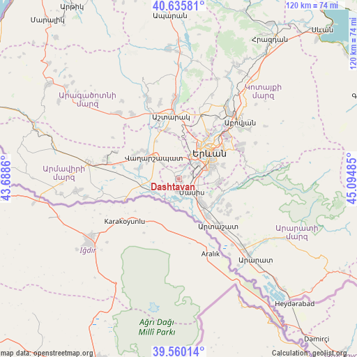
| Upper-left | 40.63581°, | 43.6886° |
| Center: | 40.1001°, | 44.39172° |
| Lower-right: | 39.56014°, | 45.09485° |
| Map W x H: | 119.6×119.6 km | = 74.3×74.3mi |
| max Lat: | 41.24358° ⇑68.2% North |
| Dashtavan: | 40.1001° |
| min Lat: | ⇓31.8% South 38.90292° |
| min Long | Dashtavan | max Long |
| 43.74722° | 44.39172° | 46.5446° |
| W 36.9%⇐ | ⇒63.1% E |
Elevation
Elevation of Dashtavan is 836 m = 2743 ft, and this is 465.5 m = 1527 ft below average elevation for this country.
| Max E: |
2169 m = 7116 ft | 90.1% |
| Avg. | 1301.5 m = 4270 ft | |
| Dashtavan | 836 m = 2743 ft | |
Min E: |
440 m = 1444 ft | 9.9% |
See also: Armenia elevation on elevation.city.
Geographical zone
Dashtavan is located in North temperate zone (between Tropic of Cancer and the Arctic Circle). Distance of this Northern Tropic circle is 1852.8 km =1151.3 mi to South.| Distance of | km | miles | from Dashtavan |
|---|---|---|---|
| North Pole | 5548.3 | 3447.6 | to North |
| Arctic Circle | 2942.5 | 1828.4 | to North |
| Tropic Cancer | 1852.8 | 1151.3 | to South |
| Equator | 4458.7 | 2770.5 | to South |


Nearby cities:
15 places around Dashtavan: (largest is in red/bold)
• Arbat’
4.4 km =2.7 mi,  12°
12°
• Arevashat
5.1 km =3.2 mi,  344°
344°
• Darakert
2 km =1.2 mi,  72°
72°
• Geghanist
6.1 km =3.8 mi,  32°
32°
• Ghukasavan
3.8 km =2.4 mi, 34°
• Hayanist
2.7 km =1.7 mi,  334°
334°
• Hovtashat
4 km =2.5 mi,  265°
265°
• Masis
4.4 km =2.7 mi,  151°
151°
• Musalerr
6.3 km =3.9 mi,  349°
349°
• Nizami
1.5 km =0.9 mi,  128°
128°
• Norabats’
3.6 km =2.2 mi,  80°
80°
• Sayat’-Nova
2.9 km =1.8 mi,  165°
165°
• Sis
4.7 km =2.9 mi,  182°
182°
• Voskehat
7 km =4.3 mi,  311°
311°
• Zorak
1 km =0.6 mi, 165°
Sources, notices
• [Note1] Compared only with cities in Armenia existing in our database
• [Src1] Map data: © OpenStreetMap contributors (CC-BY-SA)
• [Src2] Other city data from geonames.org with taken over terms of usage.
• [Src3] Geographical zone / Annual Mean Temperature by Robert A. Rohde @ Wikipedia
