Ranchos geodata
Ranchos (Buenos Aires) is a seat of a second-order administrative division; located in Argentina in America/Argentina/Buenos_Aires (GMT-3) time zone. In our database, there are 785 cities with bigger population. Compared to other cities in Argentina, 80.1% of cities are located further ↑North; 86.5% of cities are located further ←West and 93.1% of cities have higher elevation than Ranchos. Note1


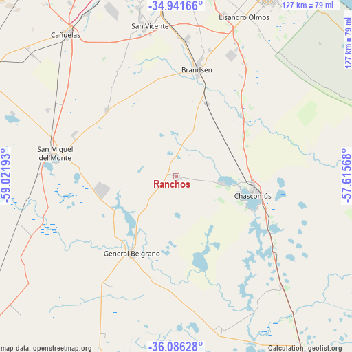
Ranchos GPS coordinates[2]
35° 30' 57.636" South, 58° 19' 7.68" West
| Map corner | latitude | longitude |
|---|---|---|
| Upper-left | -34.94166°, | -59.02193° |
| Center: | -35.51601°, | -58.3188° |
| Lower-right: | -36.08628°, | -57.61568° |
| Map W x H: | 127.3×127.3 km | = 79.1×79.1mi |
| max Lat: | -21.94467° ⇑80.1% North |
| Ranchos: | -35.51601° |
| min Lat: | ⇓19.9% South -54.81084° |
| min Long | Ranchos | max Long |
| -72.88605° | -58.3188° | -53.64581° |
| W 86.5%⇐ | ⇒13.5% E |
Elevation
Elevation of Ranchos is 23 m = 75 ft, and this is 326.3 m = 1071 ft below average elevation for this country.
| Max E: |
4040 m = 13255 ft | 93.1% |
| Avg. | 349.3 m = 1146 ft | |
| Ranchos | 23 m = 75 ft | |
Min E: |
-2 m = -7 ft | 6.9% |
See also: Argentina elevation on elevation.city.
Geographical zone
Ranchos is located in South temperate zone (between Tropic of Capricorn and the Antarctic Circle). Distance of this Southern Tropic circle is 1343.1 km =834.6 mi to North.| Distance of | km | miles | from Ranchos |
|---|---|---|---|
| Equator | 3949 | 2453.8 | to North |
| Tropic Capricorn | 1343.1 | 834.6 | to North |
| Antarctic Circle | 3452.2 | 2145.1 | to South |
| South Pole | 6058.1 | 3764.3 | to South |


Nearby cities:
15 places around Ranchos: (largest is in red/bold)
• Adrogué
79.8 km =49.6 mi,  355°
355°
• Brandsen
39.4 km =24.5 mi,  11°
11°
• Castelli
78.9 km =49 mi,  143°
143°
• Cañuelas
65.3 km =40.6 mi,  321°
321°
• Chascomús
28.8 km =17.9 mi,  102°
102°
• Ensenada
81.6 km =50.7 mi,  26°
26°
• Florencio Varela
76.9 km =47.8 mi,  354°
354°
• General Belgrano
32.3 km =20.1 mi,  209°
209°
• Guernica
66.9 km =41.6 mi, 355°
• José María Ezeiza
76.7 km =47.7 mi, 345°
• La Plata
73.9 km =45.9 mi, 26°
• Lobos
79.6 km =49.5 mi,  297°
297°
• Pila
56.1 km =34.9 mi,  163°
163°
• San Miguel del Monte
45 km =28 mi,  280°
280°
• San Vicente
55.4 km =34.4 mi, 350°
Sources, notices
• [Note1] Compared only with cities in Argentina existing in our database
• [Src1] Map data: © OpenStreetMap contributors (CC-BY-SA)
• [Src2] Other city data from geonames.org with taken over terms of usage.
• [Src3] Geographical zone / Annual Mean Temperature by Robert A. Rohde @ Wikipedia
