Morón geodata
Morón (Buenos Aires) is a seat of a second-order administrative division; located in Argentina in America/Argentina/Buenos_Aires (GMT-3) time zone. With population of 319,934 people, there are 14 cities with bigger population in this country. Compared to other cities in Argentina, 74.1% of cities are located further ↑North; 82.1% of cities are located further ←West and 89.6% of cities have higher elevation than Morón. Note1


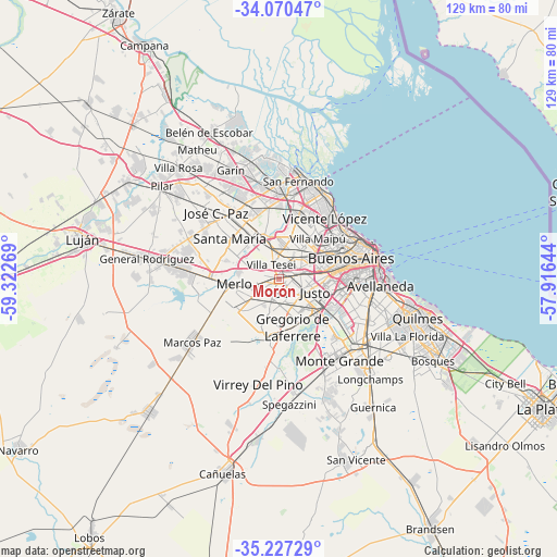
Morón GPS coordinates[2]
34° 39' 3.24" South, 58° 37' 10.416" West
| Map corner | latitude | longitude |
|---|---|---|
| Upper-left | -34.07047°, | -59.32269° |
| Center: | -34.6509°, | -58.61956° |
| Lower-right: | -35.22729°, | -57.91644° |
| Map W x H: | 128.6×128.6 km | = 79.9×79.9mi |
| max Lat: | -21.94467° ⇑74.1% North |
| Morón: | -34.6509° |
| min Lat: | ⇓25.9% South -54.81084° |
| min Long | Morón | max Long |
| -72.88605° | -58.61956° | -53.64581° |
| W 82.1%⇐ | ⇒17.9% E |
Elevation
Elevation of Morón is 29 m = 95 ft, and this is 320.3 m = 1051 ft below average elevation for this country.
| Max E: |
4040 m = 13255 ft | 89.6% |
| Avg. | 349.3 m = 1146 ft | |
| Morón | 29 m = 95 ft | |
Min E: |
-2 m = -7 ft | 10.4% |
See also: Morón elevation on elevation.city.
Geographical zone
Morón is located in South temperate zone (between Tropic of Capricorn and the Antarctic Circle). Distance of this Southern Tropic circle is 1246.9 km =774.8 mi to North.| Distance of | km | miles | from Morón |
|---|---|---|---|
| Equator | 3852.8 | 2394 | to North |
| Tropic Capricorn | 1246.9 | 774.8 | to North |
| Antarctic Circle | 3548.4 | 2204.9 | to South |
| South Pole | 6154.2 | 3824 | to South |


Nearby cities:
15 places around Morón: (largest is in red/bold)
• Belgrano
17.7 km =11 mi,  56°
56°
• Caseros
7.3 km =4.5 mi,  43°
43°
• Don Torcuato
17.4 km =10.8 mi,  357°
357°
• General San Martín
11.5 km =7.1 mi, 42°
• Hurlingham
6.8 km =4.2 mi,  352°
352°
• Ituzaingó
4.1 km =2.5 mi,  258°
258°
• Merlo
10.2 km =6.3 mi, 260°
• Muñiz
13.2 km =8.2 mi,  322°
322°
• Pontevedra
13.1 km =8.1 mi,  214°
214°
• San Justo
6.1 km =3.8 mi,  117°
117°
• San Miguel
14.7 km =9.1 mi, 324°
• Villa Lugano
13.8 km =8.6 mi,  103°
103°
• Villa Ortúzar
15.9 km =9.9 mi, 60°
• Villa Santa Rita
13.4 km =8.3 mi,  70°
70°
• Villa de Mayo
16.5 km =10.3 mi,  340°
340°
Sources, notices
• [Note1] Compared only with cities in Argentina existing in our database
• [Src1] Map data: © OpenStreetMap contributors (CC-BY-SA)
• [Src2] Other city data from geonames.org with taken over terms of usage.
• [Src3] Geographical zone / Annual Mean Temperature by Robert A. Rohde @ Wikipedia
