Garuhapé geodata
Garuhapé (Misiones) is a populated place; located in Argentina in America/Argentina/Cordoba (GMT-3) time zone. With population of 8,259 people, there are 331 cities with bigger population in this country. Compared to other cities in Argentina, 87.9% of cities are located further ↓South; 98% of cities are located further ←West and 55.7% of cities have lower elevation than Garuhapé. Note1
Administrative division(s):
- Level 1: Misiones
- Level 2: Departamento de Libertador General San Martín


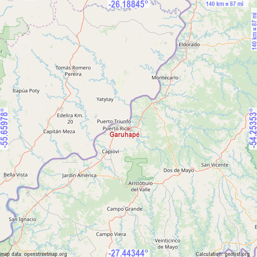
Garuhapé GPS coordinates[2]
26° 49' 3.648" South, 54° 57' 23.94" West
| Map corner | latitude | longitude |
|---|---|---|
| Upper-left | -26.18845°, | -55.65978° |
| Center: | -26.81768°, | -54.95665° |
| Lower-right: | -27.44344°, | -54.25353° |
| Map W x H: | 139.5×139.5 km | = 86.7×86.7mi |
| max Lat: | -21.94467° ⇑12.1% North |
| Garuhapé: | -26.81768° |
| min Lat: | ⇓87.9% South -54.81084° |
| min Long | Garuhapé | max Long |
| -72.88605° | -54.95665° | -53.64581° |
| W 98%⇐ | ⇒2% E |
Elevation
Elevation of Garuhapé is 177 m = 581 ft, and this is 172.3 m = 565 ft below average elevation for this country.
| Max E: |
4040 m = 13255 ft | 44.3% |
| Avg. | 349.3 m = 1146 ft | |
| Garuhapé | 177 m = 581 ft | |
Min E: |
-2 m = -7 ft | 55.7% |
See also: Argentina elevation on elevation.city.
Geographical zone
Garuhapé is located in South temperate zone (between Tropic of Capricorn and the Antarctic Circle). Distance of this Southern Tropic circle is 375.9 km =233.6 mi to North.| Distance of | km | miles | from Garuhapé |
|---|---|---|---|
| Equator | 2981.8 | 1852.8 | to North |
| Tropic Capricorn | 375.9 | 233.6 | to North |
| Antarctic Circle | 4419.3 | 2746 | to South |
| South Pole | 7025.2 | 4365.3 | to South |


Nearby cities:
15 places around Garuhapé: (largest is in red/bold)
• Aristóbulo del Valle
31.5 km =19.6 mi,  169°
169°
• Campo Grande
43.4 km =27 mi,  183°
183°
• Capioví
16.2 km =10.1 mi,  219°
219°
• Caraguatay
29.3 km =18.2 mi,  36°
36°
• Dos de Mayo
35.2 km =21.9 mi,  130°
130°
• El Alcázar
18.1 km =11.2 mi,  50°
50°
• Eldorado
56.5 km =35.1 mi, 35°
• Jardín América
36.7 km =22.8 mi,  226°
226°
• Montecarlo
34.3 km =21.3 mi, 35°
• Puerto Eldorado
52.4 km =32.6 mi,  29°
29°
• Puerto Leoni
28 km =17.4 mi, 227°
• Puerto Piray
46 km =28.6 mi, 32°
• Puerto Rico
7.1 km =4.4 mi,  289°
289°
• Ruiz de Montoya
20.6 km =12.8 mi,  206°
206°
• Santo Pipó
57.5 km =35.7 mi, 231°
Sources, notices
• [Note1] Compared only with cities in Argentina existing in our database
• [Src1] Map data: © OpenStreetMap contributors (CC-BY-SA)
• [Src2] Other city data from geonames.org with taken over terms of usage.
• [Src3] Geographical zone / Annual Mean Temperature by Robert A. Rohde @ Wikipedia
