Jardín América geodata
Jardín América (Misiones) is a populated place; located in Argentina in America/Argentina/Cordoba (GMT-3) time zone. With population of 24,905 people, there are 160 cities with bigger population in this country. Compared to other cities in Argentina, 85.8% of cities are located further ↓South; 96.5% of cities are located further ←West and 61.5% of cities have lower elevation than Jardín América. Note1


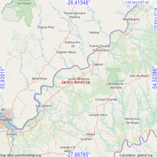
Jardín América GPS coordinates[2]
27° 2' 36.456" South, 55° 13' 37.128" West
| Map corner | latitude | longitude |
|---|---|---|
| Upper-left | -26.41548°, | -55.93011° |
| Center: | -27.04346°, | -55.22698° |
| Lower-right: | -27.66795°, | -54.52386° |
| Map W x H: | 139.3×139.3 km | = 86.6×86.6mi |
| max Lat: | -21.94467° ⇑14.2% North |
| Jardín América: | -27.04346° |
| min Lat: | ⇓85.8% South -54.81084° |
| min Long | Jardín Améric | max Long |
| -72.88605° | -55.22698° | -53.64581° |
| W 96.5%⇐ | ⇒3.5% E |
Elevation
Elevation of Jardín América is 227 m = 745 ft, and this is 122.3 m = 401 ft below average elevation for this country.
| Max E: |
4040 m = 13255 ft | 38.5% |
| Avg. | 349.3 m = 1146 ft | |
| Jardín América | 227 m = 745 ft | |
Min E: |
-2 m = -7 ft | 61.5% |
See also: Argentina elevation on elevation.city.
Geographical zone
Jardín América is located in South temperate zone (between Tropic of Capricorn and the Antarctic Circle). Distance of this Southern Tropic circle is 401 km =249.2 mi to North.| Distance of | km | miles | from Jardín América |
|---|---|---|---|
| Equator | 3007 | 1868.5 | to North |
| Tropic Capricorn | 401 | 249.2 | to North |
| Antarctic Circle | 4394.2 | 2730.4 | to South |
| South Pole | 7000.1 | 4349.7 | to South |


Nearby cities:
15 places around Jardín América: (largest is in red/bold)
• Aristóbulo del Valle
33.3 km =20.7 mi,  100°
100°
• Campo Grande
30.5 km =19 mi,  126°
126°
• Campo Ramón
50.1 km =31.1 mi,  156°
156°
• Campo Viera
36.3 km =22.6 mi,  152°
152°
• Capioví
20.7 km =12.9 mi,  52°
52°
• Garuhapé
36.7 km =22.8 mi, 46°
• General Alvear
42.9 km =26.7 mi,  172°
172°
• Gobernador Roca
28.4 km =17.6 mi,  235°
235°
• Loreto
43.5 km =27 mi,  222°
222°
• Mártires
44.7 km =27.8 mi,  199°
199°
• Puerto Leoni
8.7 km =5.4 mi,  44°
44°
• Puerto Rico
34.1 km =21.2 mi, 36°
• Ruiz de Montoya
18.8 km =11.7 mi,  69°
69°
• San Ignacio
38.5 km =23.9 mi,  232°
232°
• Santo Pipó
21 km =13 mi, 238°
Sources, notices
• [Note1] Compared only with cities in Argentina existing in our database
• [Src1] Map data: © OpenStreetMap contributors (CC-BY-SA)
• [Src2] Other city data from geonames.org with taken over terms of usage.
• [Src3] Geographical zone / Annual Mean Temperature by Robert A. Rohde @ Wikipedia
