Garruchos geodata
Garruchos (Corrientes) is a populated place; located in Argentina in America/Argentina/Cordoba (GMT-3) time zone. With population of 1,152 people, there are 745 cities with bigger population in this country. Compared to other cities in Argentina, 73.2% of cities are located further ↓South; 94.7% of cities are located further ←West and 69.6% of cities have higher elevation than Garruchos. Note1


Garruchos GPS coordinates[2]
28° 10' 19.488" South, 55° 39' 14.616" West
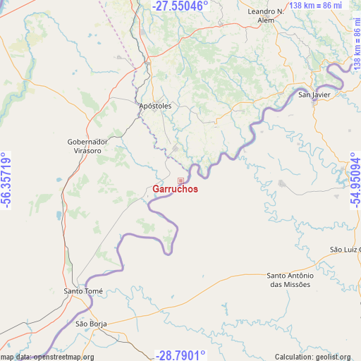
| Map corner | latitude | longitude |
|---|---|---|
| Upper-left | -27.55046°, | -56.35719° |
| Center: | -28.17208°, | -55.65406° |
| Lower-right: | -28.7901°, | -54.95094° |
| Map W x H: | 137.8×137.8 km | = 85.6×85.6mi |
| max Lat: | -21.94467° ⇑26.8% North |
| Garruchos: | -28.17208° |
| min Lat: | ⇓73.2% South -54.81084° |
| min Long | Garruchos | max Long |
| -72.88605° | -55.65406° | -53.64581° |
| W 94.7%⇐ | ⇒5.3% E |
Elevation
Elevation of Garruchos is 80 m = 262 ft, and this is 269.3 m = 884 ft below average elevation for this country.
| Max E: |
4040 m = 13255 ft | 69.6% |
| Avg. | 349.3 m = 1146 ft | |
| Garruchos | 80 m = 262 ft | |
Min E: |
-2 m = -7 ft | 30.4% |
See also: Argentina elevation on elevation.city.
Geographical zone
Garruchos is located in South temperate zone (between Tropic of Capricorn and the Antarctic Circle). Distance of this Southern Tropic circle is 526.5 km =327.2 mi to North.| Distance of | km | miles | from Garruchos |
|---|---|---|---|
| Equator | 3132.4 | 1946.4 | to North |
| Tropic Capricorn | 526.5 | 327.2 | to North |
| Antarctic Circle | 4268.7 | 2652.4 | to South |
| South Pole | 6874.6 | 4271.7 | to South |


Nearby cities:
15 places around Garruchos: (largest is in red/bold)
• Apóstoles
30.3 km =18.8 mi,  341°
341°
• Arroyo del Medio
58.2 km =36.2 mi,  24°
24°
• Azara
12.5 km =7.8 mi,  349°
349°
• Cerro Azul
61.9 km =38.5 mi,  14°
14°
• Concepción de la Sierra
24.8 km =15.4 mi,  31°
31°
• Dos Arroyos
65.7 km =40.8 mi,  36°
36°
• Gobernador Virasora
39.6 km =24.6 mi,  290°
290°
• Mojón Grande
70.8 km =44 mi, 43°
• Picada Gobernador López
68.7 km =42.7 mi, 35°
• San Carlos
53.1 km =33 mi,  333°
333°
• San Javier
60.8 km =37.8 mi,  56°
56°
• San José
46.5 km =28.9 mi, 344°
• Santa María
35.8 km =22.2 mi, 42°
• Santo Tomé
56.5 km =35.1 mi,  222°
222°
• Tres Capones
19 km =11.8 mi, 14°
Sources, notices
• [Note1] Compared only with cities in Argentina existing in our database
• [Src1] Map data: © OpenStreetMap contributors (CC-BY-SA)
• [Src2] Other city data from geonames.org with taken over terms of usage.
• [Src3] Geographical zone / Annual Mean Temperature by Robert A. Rohde @ Wikipedia
