Cerro Azul geodata
Cerro Azul (Misiones) is a populated place; located in Argentina in America/Argentina/Cordoba (GMT-3) time zone. With population of 5,323 people, there are 431 cities with bigger population in this country. Compared to other cities in Argentina, 78.5% of cities are located further ↓South; 95.4% of cities are located further ←West and 64.4% of cities have lower elevation than Cerro Azul. Note1


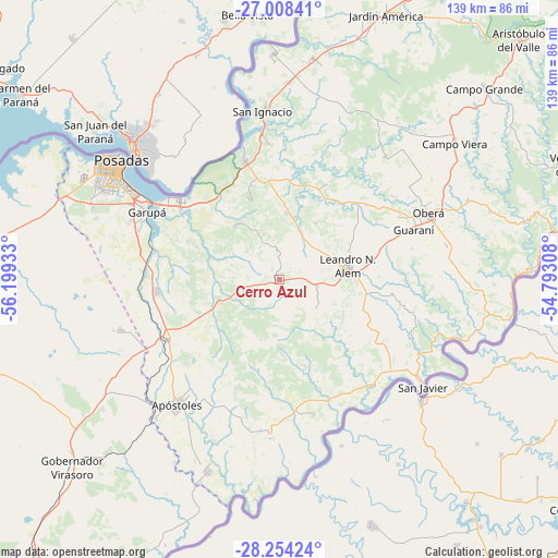
Cerro Azul GPS coordinates[2]
27° 37' 59.16" South, 55° 29' 46.32" West
| Map corner | latitude | longitude |
|---|---|---|
| Upper-left | -27.00841°, | -56.19933° |
| Center: | -27.6331°, | -55.4962° |
| Lower-right: | -28.25424°, | -54.79308° |
| Map W x H: | 138.5×138.5 km | = 86.1×86.1mi |
| max Lat: | -21.94467° ⇑21.5% North |
| Cerro Azul: | -27.6331° |
| min Lat: | ⇓78.5% South -54.81084° |
| min Long | Cerro Azul | max Long |
| -72.88605° | -55.4962° | -53.64581° |
| W 95.4%⇐ | ⇒4.6% E |
Elevation
Elevation of Cerro Azul is 263 m = 863 ft, and this is 86.3 m = 283 ft below average elevation for this country.
| Max E: |
4040 m = 13255 ft | 35.6% |
| Avg. | 349.3 m = 1146 ft | |
| Cerro Azul | 263 m = 863 ft | |
Min E: |
-2 m = -7 ft | 64.4% |
See also: Argentina elevation on elevation.city.
Geographical zone
Cerro Azul is located in South temperate zone (between Tropic of Capricorn and the Antarctic Circle). Distance of this Southern Tropic circle is 466.6 km =289.9 mi to North.| Distance of | km | miles | from Cerro Azul |
|---|---|---|---|
| Equator | 3072.5 | 1909.2 | to North |
| Tropic Capricorn | 466.6 | 289.9 | to North |
| Antarctic Circle | 4328.7 | 2689.7 | to South |
| South Pole | 6934.5 | 4308.9 | to South |


Nearby cities:
15 places around Cerro Azul: (largest is in red/bold)
• Almafuerte
16.7 km =10.4 mi,  33°
33°
• Arroyo del Medio
11.6 km =7.2 mi,  128°
128°
• Bonpland
16.9 km =10.5 mi,  6°
6°
• Candelaria
31.2 km =19.4 mi,  308°
308°
• Cerro Corá
17.4 km =10.8 mi,  320°
320°
• Dos Arroyos
25.1 km =15.6 mi,  107°
107°
• Guaraní
35.2 km =21.9 mi,  69°
69°
• Leandro N. Alem
17.2 km =10.7 mi,  78°
78°
• Loreto
33.6 km =20.9 mi,  355°
355°
• Mojón Grande
34.6 km =21.5 mi,  104°
104°
• Mártires
26.2 km =16.3 mi, 26°
• Picada Gobernador López
25 km =15.5 mi, 99°
• San José
32 km =19.9 mi,  241°
241°
• Santa Ana
30.7 km =19.1 mi,  344°
344°
• Santa María
34.7 km =21.6 mi,  165°
165°
Sources, notices
• [Note1] Compared only with cities in Argentina existing in our database
• [Src1] Map data: © OpenStreetMap contributors (CC-BY-SA)
• [Src2] Other city data from geonames.org with taken over terms of usage.
• [Src3] Geographical zone / Annual Mean Temperature by Robert A. Rohde @ Wikipedia
