San José geodata
San José (Misiones) is a populated place; located in Argentina in America/Argentina/Cordoba (GMT-3) time zone. With population of 6,452 people, there are 384 cities with bigger population in this country. Compared to other cities in Argentina, 76.5% of cities are located further ↓South; 94.3% of cities are located further ←West and 54.2% of cities have lower elevation than San José. Note1


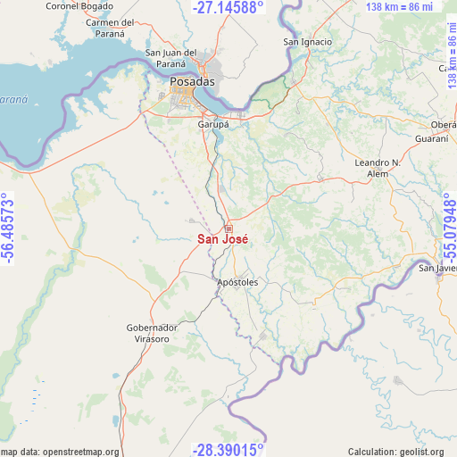
San José GPS coordinates[2]
27° 46' 11.244" South, 55° 46' 57.36" West
| Map corner | latitude | longitude |
|---|---|---|
| Upper-left | -27.14588°, | -56.48573° |
| Center: | -27.76979°, | -55.7826° |
| Lower-right: | -28.39015°, | -55.07948° |
| Map W x H: | 138.3×138.4 km | = 85.9×86mi |
| max Lat: | -21.94467° ⇑23.5% North |
| San José: | -27.76979° |
| min Lat: | ⇓76.5% South -54.81084° |
| min Long | San José | max Long |
| -72.88605° | -55.7826° | -53.64581° |
| W 94.3%⇐ | ⇒5.7% E |
Elevation
Elevation of San José is 169 m = 554 ft, and this is 180.3 m = 592 ft below average elevation for this country.
| Max E: |
4040 m = 13255 ft | 45.8% |
| Avg. | 349.3 m = 1146 ft | |
| San José | 169 m = 554 ft | |
Min E: |
-2 m = -7 ft | 54.2% |
See also: Argentina elevation on elevation.city.
Geographical zone
San José is located in South temperate zone (between Tropic of Capricorn and the Antarctic Circle). Distance of this Southern Tropic circle is 481.8 km =299.4 mi to North.| Distance of | km | miles | from San José |
|---|---|---|---|
| Equator | 3087.7 | 1918.6 | to North |
| Tropic Capricorn | 481.8 | 299.4 | to North |
| Antarctic Circle | 4313.5 | 2680.3 | to South |
| South Pole | 6919.4 | 4299.5 | to South |


Nearby cities:
15 places around San José: (largest is in red/bold)
• Apóstoles
16.3 km =10.1 mi,  169°
169°
• Arroyo del Medio
38.1 km =23.7 mi,  77°
77°
• Azara
34 km =21.1 mi,  162°
162°
• Bonpland
43.9 km =27.3 mi,  43°
43°
• Candelaria
34.7 km =21.6 mi,  6°
6°
• Cerro Azul
32 km =19.9 mi,  61°
61°
• Cerro Corá
33.3 km =20.7 mi,  30°
30°
• Concepción de la Sierra
35 km =21.7 mi,  132°
132°
• Garruchos
46.5 km =28.9 mi, 164°
• Garupá
32.4 km =20.1 mi,  351°
351°
• Gobernador Virasora
39.7 km =24.7 mi,  218°
218°
• Posadas
46.2 km =28.7 mi, 345°
• San Carlos
11.6 km =7.2 mi,  283°
283°
• Santa María
41.2 km =25.6 mi,  116°
116°
• Tres Capones
31.6 km =19.6 mi,  146°
146°
Sources, notices
• [Note1] Compared only with cities in Argentina existing in our database
• [Src1] Map data: © OpenStreetMap contributors (CC-BY-SA)
• [Src2] Other city data from geonames.org with taken over terms of usage.
• [Src3] Geographical zone / Annual Mean Temperature by Robert A. Rohde @ Wikipedia
