Villa María geodata
Villa María (Cordoba) is a seat of a second-order administrative division; located in Argentina in America/Argentina/Cordoba (GMT-3) time zone. With population of 92,453 people, there are 42 cities with bigger population in this country. Compared to other cities in Argentina, 55.8% of cities are located further ↑North; 53.5% of cities are located further →East and 58.5% of cities have lower elevation than Villa María. Note1


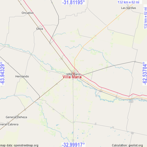
Villa María GPS coordinates[2]
32° 24' 27.036" South, 63° 14' 24.576" West
| Map corner | latitude | longitude |
|---|---|---|
| Upper-left | -31.81195°, | -63.94329° |
| Center: | -32.40751°, | -63.24016° |
| Lower-right: | -32.99917°, | -62.53704° |
| Map W x H: | 132×132 km | = 82×82mi |
| max Lat: | -21.94467° ⇑55.8% North |
| Villa María: | -32.40751° |
| min Lat: | ⇓44.2% South -54.81084° |
| min Long | Villa María | max Long |
| -72.88605° | -63.24016° | -53.64581° |
| W 46.5%⇐ | ⇒53.5% E |
Elevation
Elevation of Villa María is 202 m = 663 ft, and this is 147.3 m = 483 ft below average elevation for this country.
| Max E: |
4040 m = 13255 ft | 41.5% |
| Avg. | 349.3 m = 1146 ft | |
| Villa María | 202 m = 663 ft | |
Min E: |
-2 m = -7 ft | 58.5% |
See also: Villa María elevation on elevation.city.
Geographical zone
Villa María is located in South temperate zone (between Tropic of Capricorn and the Antarctic Circle). Distance of this Southern Tropic circle is 997.5 km =619.8 mi to North.| Distance of | km | miles | from Villa María |
|---|---|---|---|
| Equator | 3603.4 | 2239 | to North |
| Tropic Capricorn | 997.5 | 619.8 | to North |
| Antarctic Circle | 3797.8 | 2359.8 | to South |
| South Pole | 6403.7 | 3979.1 | to South |


Nearby cities:
15 places around Villa María: (largest is in red/bold)
• Arroyo Cabral
17.7 km =11 mi,  238°
238°
• Cintra
56.4 km =35 mi,  78°
78°
• Dalmacio Vélez Sársfield
39.1 km =24.3 mi,  234°
234°
• Hernando
46.3 km =28.8 mi,  267°
267°
• Idiazábal
49.2 km =30.6 mi,  156°
156°
• James Craik
34.7 km =21.6 mi,  322°
322°
• La Playosa
39.4 km =24.5 mi,  29°
29°
• Las Perdices
54.3 km =33.7 mi, 233°
• Morrison
43.4 km =27 mi,  118°
118°
• Oliva
51.2 km =31.8 mi, 322°
• Pasco
39 km =24.2 mi,  194°
194°
• Pozo del Molle
52.7 km =32.7 mi, 34°
• Ticino
36.7 km =22.8 mi,  210°
210°
• Tío Pujio
17.2 km =10.7 mi, 320°
• Villa Nueva
2.9 km =1.8 mi, 193°
Sources, notices
• [Note1] Compared only with cities in Argentina existing in our database
• [Src1] Map data: © OpenStreetMap contributors (CC-BY-SA)
• [Src2] Other city data from geonames.org with taken over terms of usage.
• [Src3] Geographical zone / Annual Mean Temperature by Robert A. Rohde @ Wikipedia
