Oliva geodata
Oliva (Cordoba) is a seat of a second-order administrative division; located in Argentina in America/Argentina/Cordoba (GMT-3) time zone. With population of 11,629 people, there are 263 cities with bigger population in this country. Compared to other cities in Argentina, 52.3% of cities are located further ↑North; 56.4% of cities are located further →East and 64.9% of cities have lower elevation than Oliva. Note1


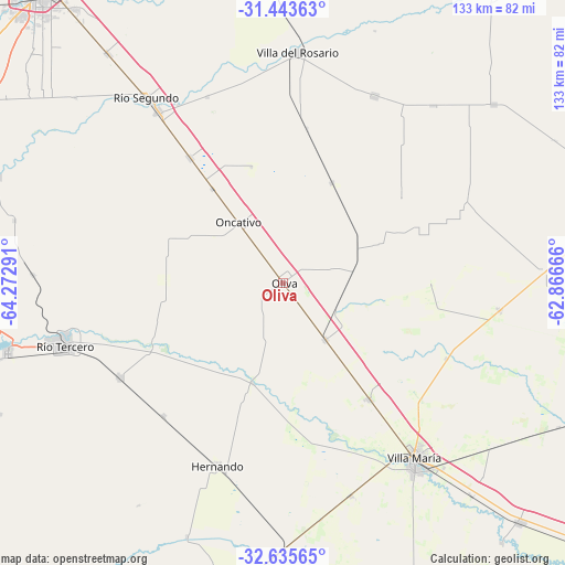
Oliva GPS coordinates[2]
32° 2' 29.688" South, 63° 34' 11.208" West
| Map corner | latitude | longitude |
|---|---|---|
| Upper-left | -31.44363°, | -64.27291° |
| Center: | -32.04158°, | -63.56978° |
| Lower-right: | -32.63565°, | -62.86666° |
| Map W x H: | 132.5×132.5 km | = 82.3×82.3mi |
| max Lat: | -21.94467° ⇑52.3% North |
| Oliva: | -32.04158° |
| min Lat: | ⇓47.7% South -54.81084° |
| min Long | Oliva | max Long |
| -72.88605° | -63.56978° | -53.64581° |
| W 43.6%⇐ | ⇒56.4% E |
Elevation
Elevation of Oliva is 267 m = 876 ft, and this is 82.3 m = 270 ft below average elevation for this country.
| Max E: |
4040 m = 13255 ft | 35.1% |
| Avg. | 349.3 m = 1146 ft | |
| Oliva | 267 m = 876 ft | |
Min E: |
-2 m = -7 ft | 64.9% |
See also: Argentina elevation on elevation.city.
Geographical zone
Oliva is located in South temperate zone (between Tropic of Capricorn and the Antarctic Circle). Distance of this Southern Tropic circle is 956.8 km =594.5 mi to North.| Distance of | km | miles | from Oliva |
|---|---|---|---|
| Equator | 3562.7 | 2213.8 | to North |
| Tropic Capricorn | 956.8 | 594.5 | to North |
| Antarctic Circle | 3838.5 | 2385.1 | to South |
| South Pole | 6444.4 | 4004.4 | to South |


Nearby cities:
15 places around Oliva: (largest is in red/bold)
• Arroyo Cabral
52.4 km =32.6 mi,  162°
162°
• Carrilobo
46.6 km =29 mi,  66°
66°
• Costa Sacate
47.3 km =29.4 mi,  337°
337°
• Hernando
45.5 km =28.3 mi,  199°
199°
• James Craik
16.5 km =10.3 mi,  143°
143°
• La Playosa
51.2 km =31.8 mi,  97°
97°
• Laguna Larga
36.7 km =22.8 mi,  323°
323°
• Las Junturas
26 km =16.2 mi,  25°
25°
• Oncativo
17.7 km =11 mi, 323°
• Pilar
49.8 km =30.9 mi, 324°
• Tancacha
44.7 km =27.8 mi,  239°
239°
• Tío Pujio
34 km =21.1 mi, 143°
• Villa Ascasubi
33.2 km =20.6 mi,  245°
245°
• Villa María
51.2 km =31.8 mi, 142°
• Villa Nueva
53 km =32.9 mi,  145°
145°
Sources, notices
• [Note1] Compared only with cities in Argentina existing in our database
• [Src1] Map data: © OpenStreetMap contributors (CC-BY-SA)
• [Src2] Other city data from geonames.org with taken over terms of usage.
• [Src3] Geographical zone / Annual Mean Temperature by Robert A. Rohde @ Wikipedia
