Hernando geodata
Hernando (Cordoba) is a populated place; located in Argentina in America/Argentina/Cordoba (GMT-3) time zone. With population of 10,486 people, there are 280 cities with bigger population in this country. Compared to other cities in Argentina, 56% of cities are located further ↑North; 58.2% of cities are located further →East and 65.2% of cities have lower elevation than Hernando. Note1


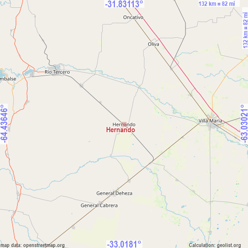
Hernando GPS coordinates[2]
32° 25' 35.652" South, 63° 43' 59.988" West
| Map corner | latitude | longitude |
|---|---|---|
| Upper-left | -31.83113°, | -64.43646° |
| Center: | -32.42657°, | -63.73333° |
| Lower-right: | -33.0181°, | -63.03021° |
| Map W x H: | 132×132 km | = 82×82mi |
| max Lat: | -21.94467° ⇑56% North |
| Hernando: | -32.42657° |
| min Lat: | ⇓44% South -54.81084° |
| min Long | Hernando | max Long |
| -72.88605° | -63.73333° | -53.64581° |
| W 41.8%⇐ | ⇒58.2% E |
Elevation
Elevation of Hernando is 279 m = 915 ft, and this is 70.3 m = 231 ft below average elevation for this country.
| Max E: |
4040 m = 13255 ft | 34.8% |
| Avg. | 349.3 m = 1146 ft | |
| Hernando | 279 m = 915 ft | |
Min E: |
-2 m = -7 ft | 65.2% |
See also: Argentina elevation on elevation.city.
Geographical zone
Hernando is located in South temperate zone (between Tropic of Capricorn and the Antarctic Circle). Distance of this Southern Tropic circle is 999.6 km =621.1 mi to North.| Distance of | km | miles | from Hernando |
|---|---|---|---|
| Equator | 3605.5 | 2240.4 | to North |
| Tropic Capricorn | 999.6 | 621.1 | to North |
| Antarctic Circle | 3795.7 | 2358.5 | to South |
| South Pole | 6401.6 | 3977.8 | to South |


Nearby cities:
15 places around Hernando: (largest is in red/bold)
• Arroyo Cabral
32 km =19.9 mi,  102°
102°
• Dalmacio Vélez Sársfield
25 km =15.5 mi,  144°
144°
• General Cabrera
44.9 km =27.9 mi,  196°
196°
• James Craik
38.7 km =24 mi,  40°
40°
• Las Perdices
30.3 km =18.8 mi,  175°
175°
• Los Cóndores
52.5 km =32.6 mi,  283°
283°
• Oliva
45.5 km =28.3 mi,  19°
19°
• Pasco
51.1 km =31.8 mi,  134°
134°
• Río Tercero
45.6 km =28.3 mi,  308°
308°
• Tancacha
30.9 km =19.2 mi, 311°
• Ticino
40.7 km =25.3 mi, 136°
• Tío Pujio
38.7 km =24 mi,  66°
66°
• Villa Ascasubi
32.8 km =20.4 mi,  333°
333°
• Villa María
46.3 km =28.8 mi,  87°
87°
• Villa Nueva
45.6 km =28.3 mi, 90°
Sources, notices
• [Note1] Compared only with cities in Argentina existing in our database
• [Src1] Map data: © OpenStreetMap contributors (CC-BY-SA)
• [Src2] Other city data from geonames.org with taken over terms of usage.
• [Src3] Geographical zone / Annual Mean Temperature by Robert A. Rohde @ Wikipedia
