Arroyo Cabral geodata
Arroyo Cabral (Cordoba) is a populated place; located in Argentina in America/Argentina/Cordoba (GMT-3) time zone. With population of 2,727 people, there are 574 cities with bigger population in this country. Compared to other cities in Argentina, 56.8% of cities are located further ↑North; 54.5% of cities are located further →East and 61.2% of cities have lower elevation than Arroyo Cabral. Note1


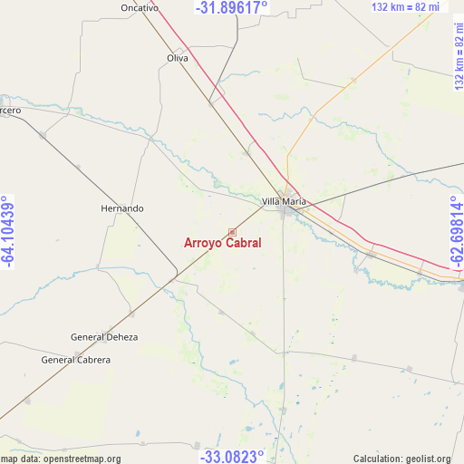
Arroyo Cabral GPS coordinates[2]
32° 29' 28.284" South, 63° 24' 4.536" West
| Map corner | latitude | longitude |
|---|---|---|
| Upper-left | -31.89617°, | -64.10439° |
| Center: | -32.49119°, | -63.40126° |
| Lower-right: | -33.0823°, | -62.69814° |
| Map W x H: | 131.9×131.9 km | = 82×82mi |
| max Lat: | -21.94467° ⇑56.8% North |
| Arroyo Cabral: | -32.49119° |
| min Lat: | ⇓43.2% South -54.81084° |
| min Long | Arroyo Cabral | max Long |
| -72.88605° | -63.40126° | -53.64581° |
| W 45.5%⇐ | ⇒54.5% E |
Elevation
Elevation of Arroyo Cabral is 223 m = 732 ft, and this is 126.3 m = 414 ft below average elevation for this country.
| Max E: |
4040 m = 13255 ft | 38.8% |
| Avg. | 349.3 m = 1146 ft | |
| Arroyo Cabral | 223 m = 732 ft | |
Min E: |
-2 m = -7 ft | 61.2% |
See also: Argentina elevation on elevation.city.
Geographical zone
Arroyo Cabral is located in South temperate zone (between Tropic of Capricorn and the Antarctic Circle). Distance of this Southern Tropic circle is 1006.8 km =625.6 mi to North.| Distance of | km | miles | from Arroyo Cabral |
|---|---|---|---|
| Equator | 3612.7 | 2244.8 | to North |
| Tropic Capricorn | 1006.8 | 625.6 | to North |
| Antarctic Circle | 3788.5 | 2354.1 | to South |
| South Pole | 6394.4 | 3973.3 | to South |


Nearby cities:
15 places around Arroyo Cabral: (largest is in red/bold)
• Dalmacio Vélez Sársfield
21.4 km =13.3 mi,  231°
231°
• Etruria
52 km =32.3 mi,  163°
163°
• General Cabrera
56.8 km =35.3 mi, 230°
• Hernando
32 km =19.9 mi,  282°
282°
• Idiazábal
49.8 km =30.9 mi,  136°
136°
• James Craik
37.2 km =23.1 mi,  350°
350°
• La Playosa
55.7 km =34.6 mi,  38°
38°
• Las Perdices
36.7 km =22.8 mi, 231°
• Morrison
54.4 km =33.8 mi,  102°
102°
• Oliva
52.4 km =32.6 mi,  342°
342°
• Pasco
29 km =18 mi,  169°
169°
• Ticino
22.7 km =14.1 mi,  188°
188°
• Tío Pujio
23 km =14.3 mi,  10°
10°
• Villa María
17.7 km =11 mi,  58°
58°
• Villa Nueva
15.8 km =9.8 mi,  65°
65°
Sources, notices
• [Note1] Compared only with cities in Argentina existing in our database
• [Src1] Map data: © OpenStreetMap contributors (CC-BY-SA)
• [Src2] Other city data from geonames.org with taken over terms of usage.
• [Src3] Geographical zone / Annual Mean Temperature by Robert A. Rohde @ Wikipedia
