Susques geodata
Susques (Jujuy) is a seat of a second-order administrative division; located in Argentina in America/Argentina/Salta (GMT-3) time zone. In our database, there are 785 cities with bigger population. Compared to other cities in Argentina, 98.7% of cities are located further ↓South; 84.4% of cities are located further →East and 99.6% of cities have lower elevation than Susques. Note1


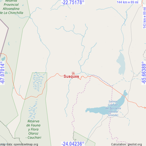
Susques GPS coordinates[2]
23° 23' 55.104" South, 66° 22' 1.236" West
| Map corner | latitude | longitude |
|---|---|---|
| Upper-left | -22.75178°, | -67.07014° |
| Center: | -23.39864°, | -66.36701° |
| Lower-right: | -24.04236°, | -65.66389° |
| Map W x H: | 143.5×143.5 km | = 89.2×89.2mi |
| max Lat: | -21.94467° ⇑1.3% North |
| Susques: | -23.39864° |
| min Lat: | ⇓98.7% South -54.81084° |
| min Long | Susques | max Long |
| -72.88605° | -66.36701° | -53.64581° |
| W 15.6%⇐ | ⇒84.4% E |
Elevation
Elevation of Susques is 3605 m = 11827 ft, and this is 3255.7 m = 10681 ft above average elevation for this country.
| Max E: |
4040 m = 13255 ft | 0.40000000000001% |
| Susques | 3605 m 11827 ft | |
| Avg. | 349.3 m = 1146 ft | |
Min E: |
-2 m = -7 ft | 99.6% |
See also: Argentina elevation on elevation.city.
Geographical zone
Susques is located in South Torrid zone (between Equator and Tropic of Capricorn). Distance of this Southern Tropic circle is 4.2 km =2.6 mi to South.| Distance of | km | miles | from Susques |
|---|---|---|---|
| Equator | 2601.7 | 1616.6 | to North |
| Tropic Capricorn | 4.2 | 2.6 | to South |
| Antarctic Circle | 4799.5 | 2982.3 | to South |
| South Pole | 7405.4 | 4601.5 | to South |


Nearby cities:
15 places around Susques: (largest is in red/bold)
• Abra Pampa
101.9 km =63.3 mi,  42°
42°
• El Aguilar
73 km =45.4 mi,  73°
73°
• Humahuaca
106 km =65.9 mi,  78°
78°
• Iruya
135.6 km =84.3 mi,  60°
60°
• La Poma
148.1 km =92 mi,  173°
173°
• Maimará
100.9 km =62.7 mi,  104°
104°
• Palpalá
151.4 km =94.1 mi,  129°
129°
• Rinconada
108.4 km =67.4 mi,  10°
10°
• San Antonio
150.4 km =93.5 mi,  135°
135°
• San Antonio de los Cobres
91.2 km =56.7 mi,  176°
176°
• San Salvador de Jujuy
140.3 km =87.2 mi, 129°
• Santa Rosa de Tastil
123.7 km =76.9 mi,  161°
161°
• Tilcara
101.1 km =62.8 mi, 101°
• Tumbaya
105 km =65.2 mi,  119°
119°
• Valle Grande
145 km =90.1 mi,  93°
93°
Sources, notices
• [Note1] Compared only with cities in Argentina existing in our database
• [Src1] Map data: © OpenStreetMap contributors (CC-BY-SA)
• [Src2] Other city data from geonames.org with taken over terms of usage.
• [Src3] Geographical zone / Annual Mean Temperature by Robert A. Rohde @ Wikipedia
