General Roca geodata
General Roca (Cordoba) is a populated place; located in Argentina in America/Argentina/Cordoba (GMT-3) time zone. With population of 2,597 people, there are 583 cities with bigger population in this country. Compared to other cities in Argentina, 59% of cities are located further ↑North; 55.6% of cities are located further ←West and 66.6% of cities have higher elevation than General Roca. Note1


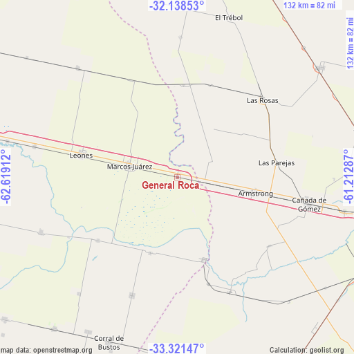
General Roca GPS coordinates[2]
32° 43' 55.056" South, 61° 54' 57.564" West
| Map corner | latitude | longitude |
|---|---|---|
| Upper-left | -32.13853°, | -62.61912° |
| Center: | -32.73196°, | -61.91599° |
| Lower-right: | -33.32147°, | -61.21287° |
| Map W x H: | 131.5×131.5 km | = 81.7×81.7mi |
| max Lat: | -21.94467° ⇑59% North |
| General Roca: | -32.73196° |
| min Lat: | ⇓41% South -54.81084° |
| min Long | General Roca | max Long |
| -72.88605° | -61.91599° | -53.64581° |
| W 55.6%⇐ | ⇒44.4% E |
Elevation
Elevation of General Roca is 90 m = 295 ft, and this is 259.3 m = 851 ft below average elevation for this country.
| Max E: |
4040 m = 13255 ft | 66.6% |
| Avg. | 349.3 m = 1146 ft | |
| General Roca | 90 m = 295 ft | |
Min E: |
-2 m = -7 ft | 33.4% |
See also: Argentina elevation on elevation.city.
Geographical zone
General Roca is located in South temperate zone (between Tropic of Capricorn and the Antarctic Circle). Distance of this Southern Tropic circle is 1033.5 km =642.2 mi to North.| Distance of | km | miles | from General Roca |
|---|---|---|---|
| Equator | 3639.5 | 2261.5 | to North |
| Tropic Capricorn | 1033.5 | 642.2 | to North |
| Antarctic Circle | 3761.7 | 2337.4 | to South |
| South Pole | 6367.6 | 3956.6 | to South |


Nearby cities:
15 places around General Roca: (largest is in red/bold)
• Armstrong
29.9 km =18.6 mi,  100°
100°
• Camilo Aldao
47 km =29.2 mi,  200°
200°
• Cañada de Gómez
49.6 km =30.8 mi, 100°
• Corral de Bustos
66.1 km =41.1 mi, 202°
• Cruz Alta
32.4 km =20.1 mi,  161°
161°
• El Trébol
62.4 km =38.8 mi,  18°
18°
• General Baldissera
56.7 km =35.2 mi,  219°
219°
• Inriville
37.7 km =23.4 mi,  231°
231°
• Las Parejas
37.8 km =23.5 mi,  82°
82°
• Las Rosas
42.4 km =26.3 mi,  47°
47°
• Leones
36.5 km =22.7 mi,  282°
282°
• Los Surgentes
29.8 km =18.5 mi, 199°
• Marcos Juárez
18.2 km =11.3 mi, 282°
• Monte Buey
54.5 km =33.9 mi,  247°
247°
• Noetinger
55 km =34.2 mi,  317°
317°
Sources, notices
• [Note1] Compared only with cities in Argentina existing in our database
• [Src1] Map data: © OpenStreetMap contributors (CC-BY-SA)
• [Src2] Other city data from geonames.org with taken over terms of usage.
• [Src3] Geographical zone / Annual Mean Temperature by Robert A. Rohde @ Wikipedia
