Armstrong geodata
Armstrong (Santa Fe) is a populated place; located in Argentina in America/Argentina/Cordoba (GMT-3) time zone. With population of 10,388 people, there are 283 cities with bigger population in this country. Compared to other cities in Argentina, 59.4% of cities are located further ↑North; 57.3% of cities are located further ←West and 55.1% of cities have higher elevation than Armstrong. Note1


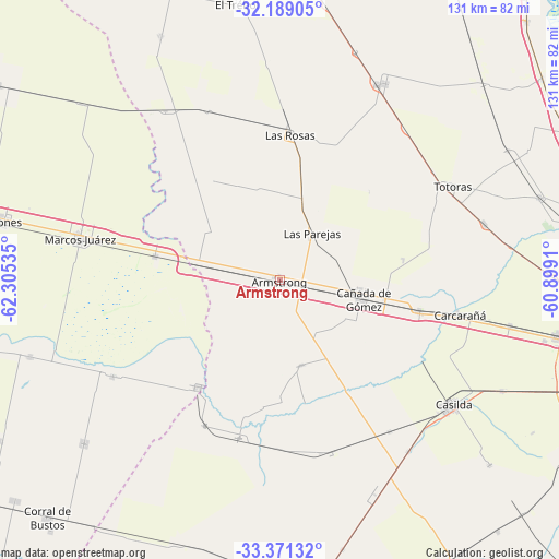
Armstrong GPS coordinates[2]
32° 46' 55.74" South, 61° 36' 7.992" West
| Map corner | latitude | longitude |
|---|---|---|
| Upper-left | -32.18905°, | -62.30535° |
| Center: | -32.78215°, | -61.60222° |
| Lower-right: | -33.37132°, | -60.8991° |
| Map W x H: | 131.5×131.5 km | = 81.7×81.7mi |
| max Lat: | -21.94467° ⇑59.4% North |
| Armstrong: | -32.78215° |
| min Lat: | ⇓40.6% South -54.81084° |
| min Long | Armstrong | max Long |
| -72.88605° | -61.60222° | -53.64581° |
| W 57.3%⇐ | ⇒42.7% E |
Elevation
Elevation of Armstrong is 122 m = 400 ft, and this is 227.3 m = 746 ft below average elevation for this country.
| Max E: |
4040 m = 13255 ft | 55.1% |
| Avg. | 349.3 m = 1146 ft | |
| Armstrong | 122 m = 400 ft | |
Min E: |
-2 m = -7 ft | 44.9% |
See also: Argentina elevation on elevation.city.
Geographical zone
Armstrong is located in South temperate zone (between Tropic of Capricorn and the Antarctic Circle). Distance of this Southern Tropic circle is 1039.1 km =645.7 mi to North.| Distance of | km | miles | from Armstrong |
|---|---|---|---|
| Equator | 3645 | 2264.9 | to North |
| Tropic Capricorn | 1039.1 | 645.7 | to North |
| Antarctic Circle | 3756.1 | 2333.9 | to South |
| South Pole | 6362 | 3953.2 | to South |


Nearby cities:
15 places around Armstrong: (largest is in red/bold)
• Camilo Aldao
59.9 km =37.2 mi,  230°
230°
• Carcarañá
42.8 km =26.6 mi,  101°
101°
• Casilda
49.9 km =31 mi,  125°
125°
• Cañada de Gómez
19.7 km =12.2 mi, 101°
• Cruz Alta
31.7 km =19.7 mi,  217°
217°
• El Trébol
65.3 km =40.6 mi,  351°
351°
• General Roca
29.9 km =18.6 mi,  280°
280°
• Inriville
61.4 km =38.2 mi,  252°
252°
• Las Parejas
13.5 km =8.4 mi,  36°
36°
• Las Rosas
34 km =21.1 mi,  3°
3°
• Leones
66.3 km =41.2 mi, 281°
• Los Surgentes
45.2 km =28.1 mi,  240°
240°
• Marcos Juárez
48.1 km =29.9 mi, 281°
• Roldán
66.2 km =41.1 mi, 101°
• Totoras
46.2 km =28.7 mi,  61°
61°
Sources, notices
• [Note1] Compared only with cities in Argentina existing in our database
• [Src1] Map data: © OpenStreetMap contributors (CC-BY-SA)
• [Src2] Other city data from geonames.org with taken over terms of usage.
• [Src3] Geographical zone / Annual Mean Temperature by Robert A. Rohde @ Wikipedia
