Devoto geodata
Devoto (Cordoba) is a populated place; located in Argentina in America/Argentina/Cordoba (GMT-3) time zone. With population of 5,597 people, there are 415 cities with bigger population in this country. Compared to other cities in Argentina, 55.5% of cities are located further ↓South; 53.3% of cities are located further ←West and 58.7% of cities have higher elevation than Devoto. Note1


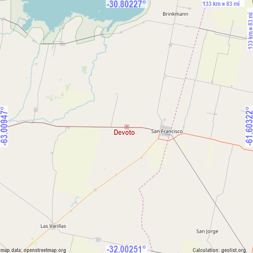
Devoto GPS coordinates[2]
31° 24' 15.516" South, 62° 18' 22.824" West
| Map corner | latitude | longitude |
|---|---|---|
| Upper-left | -30.80227°, | -63.00947° |
| Center: | -31.40431°, | -62.30634° |
| Lower-right: | -32.00251°, | -61.60322° |
| Map W x H: | 133.5×133.5 km | = 83×83mi |
| max Lat: | -21.94467° ⇑44.5% North |
| Devoto: | -31.40431° |
| min Lat: | ⇓55.5% South -54.81084° |
| min Long | Devoto | max Long |
| -72.88605° | -62.30634° | -53.64581° |
| W 53.3%⇐ | ⇒46.7% E |
Elevation
Elevation of Devoto is 112 m = 367 ft, and this is 237.3 m = 779 ft below average elevation for this country.
| Max E: |
4040 m = 13255 ft | 58.7% |
| Avg. | 349.3 m = 1146 ft | |
| Devoto | 112 m = 367 ft | |
Min E: |
-2 m = -7 ft | 41.3% |
See also: Argentina elevation on elevation.city.
Geographical zone
Devoto is located in South temperate zone (between Tropic of Capricorn and the Antarctic Circle). Distance of this Southern Tropic circle is 885.9 km =550.5 mi to North.| Distance of | km | miles | from Devoto |
|---|---|---|---|
| Equator | 3491.8 | 2169.7 | to North |
| Tropic Capricorn | 885.9 | 550.5 | to North |
| Antarctic Circle | 3909.3 | 2429.1 | to South |
| South Pole | 6515.2 | 4048.4 | to South |


Nearby cities:
15 places around Devoto: (largest is in red/bold)
• Altos de Chipión
49.9 km =31 mi,  356°
356°
• Balnearia
55.8 km =34.7 mi,  322°
322°
• Brinkmann
65.1 km =40.5 mi,  23°
23°
• Colonia San Bartolomé
42 km =26.1 mi,  250°
250°
• El Arañado
67 km =41.6 mi,  236°
236°
• El Tío
49.7 km =30.9 mi,  272°
272°
• La Francia
31.1 km =19.3 mi, 269°
• Las Varas
53.1 km =33 mi,  213°
213°
• Las Varillas
65.1 km =40.5 mi,  216°
216°
• Miramar
64.6 km =40.1 mi,  326°
326°
• Porteña
49 km =30.4 mi,  27°
27°
• San Francisco
21.4 km =13.3 mi,  97°
97°
• Sastre
60.6 km =37.7 mi,  131°
131°
• Saturnino M. Laspiur
37.1 km =23.1 mi, 206°
• Villa Concepción del Tío
49 km =30.4 mi,  280°
280°
Sources, notices
• [Note1] Compared only with cities in Argentina existing in our database
• [Src1] Map data: © OpenStreetMap contributors (CC-BY-SA)
• [Src2] Other city data from geonames.org with taken over terms of usage.
• [Src3] Geographical zone / Annual Mean Temperature by Robert A. Rohde @ Wikipedia
