Sastre geodata
Sastre (Santa Fe) is a seat of a second-order administrative division; located in Argentina in America/Argentina/Cordoba (GMT-3) time zone. With population of 5,521 people, there are 419 cities with bigger population in this country. Compared to other cities in Argentina, 50.6% of cities are located further ↓South; 56.4% of cities are located further ←West and 59.8% of cities have higher elevation than Sastre. Note1


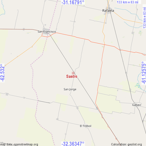
Sastre GPS coordinates[2]
31° 46' 3.432" South, 61° 49' 43.932" West
| Map corner | latitude | longitude |
|---|---|---|
| Upper-left | -31.16791°, | -62.532° |
| Center: | -31.76762°, | -61.82887° |
| Lower-right: | -32.36347°, | -61.12575° |
| Map W x H: | 132.9×132.9 km | = 82.6×82.6mi |
| max Lat: | -21.94467° ⇑49.4% North |
| Sastre: | -31.76762° |
| min Lat: | ⇓50.6% South -54.81084° |
| min Long | Sastre | max Long |
| -72.88605° | -61.82887° | -53.64581° |
| W 56.4%⇐ | ⇒43.6% E |
Elevation
Elevation of Sastre is 109 m = 358 ft, and this is 240.3 m = 788 ft below average elevation for this country.
| Max E: |
4040 m = 13255 ft | 59.8% |
| Avg. | 349.3 m = 1146 ft | |
| Sastre | 109 m = 358 ft | |
Min E: |
-2 m = -7 ft | 40.2% |
See also: Argentina elevation on elevation.city.
Geographical zone
Sastre is located in South temperate zone (between Tropic of Capricorn and the Antarctic Circle). Distance of this Southern Tropic circle is 926.3 km =575.6 mi to North.| Distance of | km | miles | from Sastre |
|---|---|---|---|
| Equator | 3532.2 | 2194.8 | to North |
| Tropic Capricorn | 926.3 | 575.6 | to North |
| Antarctic Circle | 3868.9 | 2404 | to South |
| South Pole | 6474.8 | 4023.3 | to South |


Nearby cities:
15 places around Sastre: (largest is in red/bold)
• Bella Italia
67 km =41.6 mi,  36°
36°
• Devoto
60.6 km =37.7 mi,  311°
311°
• El Trébol
49.6 km =30.8 mi,  165°
165°
• Gálvez
64.3 km =40 mi,  116°
116°
• La Francia
86.2 km =53.6 mi,  297°
297°
• Las Rosas
82.2 km =51.1 mi,  163°
163°
• Las Varas
74.5 km =46.3 mi,  267°
267°
• Las Varillas
84.9 km =52.8 mi,  262°
262°
• Noetinger
80.6 km =50.1 mi,  214°
214°
• Porteña
86.8 km =53.9 mi,  344°
344°
• Rafaela
66 km =41 mi,  29°
29°
• San Carlos Centro
69.8 km =43.4 mi,  86°
86°
• San Francisco
44.8 km =27.8 mi,  327°
327°
• San Jorge
14.6 km =9.1 mi,  191°
191°
• Saturnino M. Laspiur
62.2 km =38.6 mi,  276°
276°
Sources, notices
• [Note1] Compared only with cities in Argentina existing in our database
• [Src1] Map data: © OpenStreetMap contributors (CC-BY-SA)
• [Src2] Other city data from geonames.org with taken over terms of usage.
• [Src3] Geographical zone / Annual Mean Temperature by Robert A. Rohde @ Wikipedia
