Despeñaderos geodata
Despeñaderos (Cordoba) is a populated place; located in Argentina in America/Argentina/Cordoba (GMT-3) time zone. With population of 5,645 people, there are 411 cities with bigger population in this country. Compared to other cities in Argentina, 50% of cities are located further ↓South; 64.7% of cities are located further →East and 75.2% of cities have lower elevation than Despeñaderos. Note1


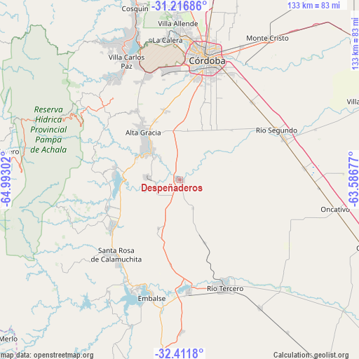
Despeñaderos GPS coordinates[2]
31° 48' 58.536" South, 64° 17' 23.604" West
| Map corner | latitude | longitude |
|---|---|---|
| Upper-left | -31.21686°, | -64.99302° |
| Center: | -31.81626°, | -64.28989° |
| Lower-right: | -32.4118°, | -63.58677° |
| Map W x H: | 132.9×132.9 km | = 82.6×82.6mi |
| max Lat: | -21.94467° ⇑50% North |
| Despeñaderos: | -31.81626° |
| min Lat: | ⇓50% South -54.81084° |
| min Long | Despeñaderos | max Long |
| -72.88605° | -64.28989° | -53.64581° |
| W 35.3%⇐ | ⇒64.7% E |
Elevation
Elevation of Despeñaderos is 451 m = 1480 ft, and this is 101.7 m = 334 ft above average elevation for this country.
| Max E: |
4040 m = 13255 ft | 24.8% |
| Despeñaderos | 451 m 1480 ft | |
| Avg. | 349.3 m = 1146 ft | |
Min E: |
-2 m = -7 ft | 75.2% |
See also: Argentina elevation on elevation.city.
Geographical zone
Despeñaderos is located in South temperate zone (between Tropic of Capricorn and the Antarctic Circle). Distance of this Southern Tropic circle is 931.7 km =578.9 mi to North.| Distance of | km | miles | from Despeñaderos |
|---|---|---|---|
| Equator | 3537.6 | 2198.2 | to North |
| Tropic Capricorn | 931.7 | 578.9 | to North |
| Antarctic Circle | 3863.5 | 2400.7 | to South |
| South Pole | 6469.4 | 4019.9 | to South |


Nearby cities:
15 places around Despeñaderos: (largest is in red/bold)
• Almafuerte
42 km =26.1 mi,  175°
175°
• Alta Gracia
22.4 km =13.9 mi,  324°
324°
• Corralito
24.9 km =15.5 mi,  158°
158°
• Embalse
42.2 km =26.2 mi,  196°
196°
• Malagueño
39.6 km =24.6 mi,  350°
350°
• Pilar
41.7 km =25.9 mi,  68°
68°
• Río Segundo
40.3 km =25 mi,  63°
63°
• Río Tercero
43 km =26.7 mi, 157°
• San Agustín
19.5 km =12.1 mi, 203°
• Santa Rosa de Calamuchita
36.5 km =22.7 mi,  219°
219°
• Toledo
39.3 km =24.4 mi,  42°
42°
• Villa Berna
43.2 km =26.8 mi,  255°
255°
• Villa General Belgrano
30.9 km =19.2 mi,  234°
234°
• Villa Rumipal
45.1 km =28 mi, 203°
• Villa del Dique
43 km =26.7 mi, 201°
Sources, notices
• [Note1] Compared only with cities in Argentina existing in our database
• [Src1] Map data: © OpenStreetMap contributors (CC-BY-SA)
• [Src2] Other city data from geonames.org with taken over terms of usage.
• [Src3] Geographical zone / Annual Mean Temperature by Robert A. Rohde @ Wikipedia
