Beltrán geodata
Beltrán (Santiago del Estero) is a populated place; located in Argentina in America/Argentina/Cordoba (GMT-3) time zone. With population of 5,321 people, there are 432 cities with bigger population in this country. Compared to other cities in Argentina, 76.3% of cities are located further ↓South; 61.8% of cities are located further →East and 54.9% of cities have lower elevation than Beltrán. Note1


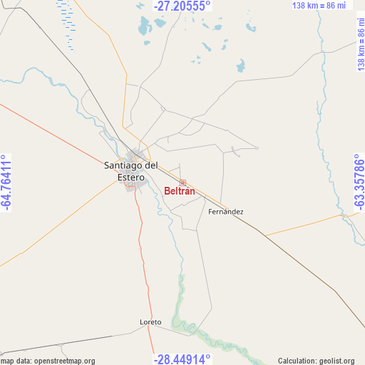
Beltrán GPS coordinates[2]
27° 49' 44.868" South, 64° 3' 39.528" West
| Map corner | latitude | longitude |
|---|---|---|
| Upper-left | -27.20555°, | -64.76411° |
| Center: | -27.82913°, | -64.06098° |
| Lower-right: | -28.44914°, | -63.35786° |
| Map W x H: | 138.3×138.3 km | = 85.9×85.9mi |
| max Lat: | -21.94467° ⇑23.7% North |
| Beltrán: | -27.82913° |
| min Lat: | ⇓76.3% South -54.81084° |
| min Long | Beltrán | max Long |
| -72.88605° | -64.06098° | -53.64581° |
| W 38.2%⇐ | ⇒61.8% E |
Elevation
Elevation of Beltrán is 172 m = 564 ft, and this is 177.3 m = 582 ft below average elevation for this country.
| Max E: |
4040 m = 13255 ft | 45.1% |
| Avg. | 349.3 m = 1146 ft | |
| Beltrán | 172 m = 564 ft | |
Min E: |
-2 m = -7 ft | 54.9% |
See also: Argentina elevation on elevation.city.
Geographical zone
Beltrán is located in South temperate zone (between Tropic of Capricorn and the Antarctic Circle). Distance of this Southern Tropic circle is 488.4 km =303.5 mi to North.| Distance of | km | miles | from Beltrán |
|---|---|---|---|
| Equator | 3094.3 | 1922.7 | to North |
| Tropic Capricorn | 488.4 | 303.5 | to North |
| Antarctic Circle | 4306.9 | 2676.2 | to South |
| South Pole | 6912.8 | 4295.4 | to South |


Nearby cities:
15 places around Beltrán: (largest is in red/bold)
• Arraga
29.2 km =18.1 mi,  212°
212°
• Brea Pozo
47.4 km =29.5 mi,  166°
166°
• Clodomira
29.2 km =18.1 mi,  346°
346°
• El Hoyo
120.9 km =75.1 mi,  42°
42°
• El Simbolar
83.5 km =51.9 mi,  259°
259°
• Fernández
19.3 km =12 mi,  121°
121°
• Garza
62.6 km =38.9 mi,  125°
125°
• La Banda
20.8 km =12.9 mi,  300°
300°
• La Cañada
31.3 km =19.4 mi,  64°
64°
• Pozo Hondo
85 km =52.8 mi,  330°
330°
• San Pedro
109.5 km =68 mi, 262°
• Santiago del Estero
20.1 km =12.5 mi,  280°
280°
• Suncho Corral
63.2 km =39.3 mi,  100°
100°
• Termas de Río Hondo
87.1 km =54.1 mi, 295°
• Villa Atamisqui
77.9 km =48.4 mi,  162°
162°
Sources, notices
• [Note1] Compared only with cities in Argentina existing in our database
• [Src1] Map data: © OpenStreetMap contributors (CC-BY-SA)
• [Src2] Other city data from geonames.org with taken over terms of usage.
• [Src3] Geographical zone / Annual Mean Temperature by Robert A. Rohde @ Wikipedia
