Arraga geodata
Arraga (Santiago del Estero) is a seat of a second-order administrative division; located in Argentina in America/Argentina/Cordoba (GMT-3) time zone. In our database, there are 785 cities with bigger population. Compared to other cities in Argentina, 74.1% of cities are located further ↓South; 63.4% of cities are located further →East and 54.2% of cities have lower elevation than Arraga. Note1


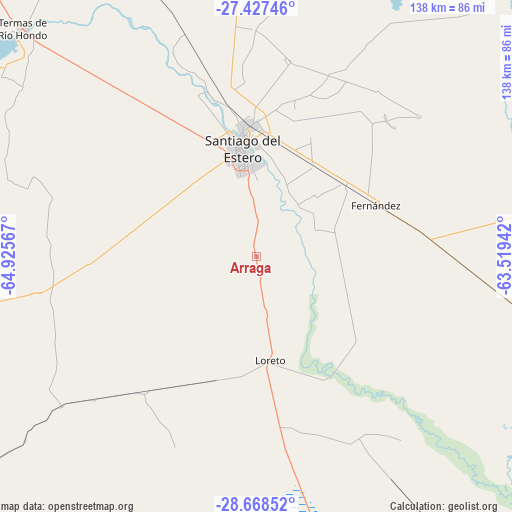
Arraga GPS coordinates[2]
28° 2' 59.208" South, 64° 13' 21.144" West
| Map corner | latitude | longitude |
|---|---|---|
| Upper-left | -27.42746°, | -64.92567° |
| Center: | -28.04978°, | -64.22254° |
| Lower-right: | -28.66852°, | -63.51942° |
| Map W x H: | 138×138 km | = 85.7×85.7mi |
| max Lat: | -21.94467° ⇑25.9% North |
| Arraga: | -28.04978° |
| min Lat: | ⇓74.1% South -54.81084° |
| min Long | Arraga | max Long |
| -72.88605° | -64.22254° | -53.64581° |
| W 36.6%⇐ | ⇒63.4% E |
Elevation
Elevation of Arraga is 169 m = 554 ft, and this is 180.3 m = 592 ft below average elevation for this country.
| Max E: |
4040 m = 13255 ft | 45.8% |
| Avg. | 349.3 m = 1146 ft | |
| Arraga | 169 m = 554 ft | |
Min E: |
-2 m = -7 ft | 54.2% |
See also: Argentina elevation on elevation.city.
Geographical zone
Arraga is located in South temperate zone (between Tropic of Capricorn and the Antarctic Circle). Distance of this Southern Tropic circle is 512.9 km =318.7 mi to North.| Distance of | km | miles | from Arraga |
|---|---|---|---|
| Equator | 3118.8 | 1937.9 | to North |
| Tropic Capricorn | 512.9 | 318.7 | to North |
| Antarctic Circle | 4282.3 | 2660.9 | to South |
| South Pole | 6888.2 | 4280.1 | to South |


Nearby cities:
15 places around Arraga: (largest is in red/bold)
• Bañado de Ovanta
107.7 km =66.9 mi,  266°
266°
• Beltrán
29.2 km =18.1 mi,  32°
32°
• Brea Pozo
34.3 km =21.3 mi,  129°
129°
• Clodomira
53.6 km =33.3 mi,  9°
9°
• El Simbolar
66.6 km =41.4 mi,  277°
277°
• Fernández
35.4 km =22 mi,  65°
65°
• Garza
68 km =42.3 mi,  99°
99°
• La Banda
35.2 km =21.9 mi,  356°
356°
• La Cañada
58.2 km =36.2 mi,  49°
49°
• Pozo Hondo
101.7 km =63.2 mi,  344°
344°
• San Pedro
93.3 km =58 mi, 276°
• Santiago del Estero
28.6 km =17.8 mi,  352°
352°
• Suncho Corral
78.9 km =49 mi,  80°
80°
• Termas de Río Hondo
88.1 km =54.7 mi,  314°
314°
• Villa Atamisqui
63.6 km =39.5 mi,  141°
141°
Sources, notices
• [Note1] Compared only with cities in Argentina existing in our database
• [Src1] Map data: © OpenStreetMap contributors (CC-BY-SA)
• [Src2] Other city data from geonames.org with taken over terms of usage.
• [Src3] Geographical zone / Annual Mean Temperature by Robert A. Rohde @ Wikipedia
