Bell Ville geodata
Bell Ville (Cordoba) is a seat of a second-order administrative division; located in Argentina in America/Argentina/Cordoba (GMT-3) time zone. With population of 35,105 people, there are 118 cities with bigger population in this country. Compared to other cities in Argentina, 57.9% of cities are located further ↑North; 50.9% of cities are located further ←West and 52.2% of cities have higher elevation than Bell Ville. Note1


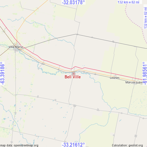
Bell Ville GPS coordinates[2]
32° 37' 33.276" South, 62° 41' 19.428" West
| Map corner | latitude | longitude |
|---|---|---|
| Upper-left | -32.03178°, | -63.39186° |
| Center: | -32.62591°, | -62.68873° |
| Lower-right: | -33.21612°, | -61.98561° |
| Map W x H: | 131.7×131.7 km | = 81.8×81.8mi |
| max Lat: | -21.94467° ⇑57.9% North |
| Bell Ville: | -32.62591° |
| min Lat: | ⇓42.1% South -54.81084° |
| min Long | Bell Ville | max Long |
| -72.88605° | -62.68873° | -53.64581° |
| W 50.9%⇐ | ⇒49.1% E |
Elevation
Elevation of Bell Ville is 132 m = 433 ft, and this is 217.3 m = 713 ft below average elevation for this country.
| Max E: |
4040 m = 13255 ft | 52.2% |
| Avg. | 349.3 m = 1146 ft | |
| Bell Ville | 132 m = 433 ft | |
Min E: |
-2 m = -7 ft | 47.8% |
See also: Argentina elevation on elevation.city.
Geographical zone
Bell Ville is located in South temperate zone (between Tropic of Capricorn and the Antarctic Circle). Distance of this Southern Tropic circle is 1021.7 km =634.9 mi to North.| Distance of | km | miles | from Bell Ville |
|---|---|---|---|
| Equator | 3627.7 | 2254.1 | to North |
| Tropic Capricorn | 1021.7 | 634.9 | to North |
| Antarctic Circle | 3773.5 | 2344.7 | to South |
| South Pole | 6379.4 | 3964 | to South |


Nearby cities:
15 places around Bell Ville: (largest is in red/bold)
• Cintra
35.7 km =22.2 mi,  5°
5°
• Idiazábal
38.4 km =23.9 mi,  236°
236°
• Inriville
55.6 km =34.5 mi,  129°
129°
• Justiniano Posse
28.7 km =17.8 mi,  177°
177°
• Laborde
60.7 km =37.7 mi,  194°
194°
• Leones
36.9 km =22.9 mi,  96°
96°
• Marcos Juárez
55.1 km =34.2 mi, 98°
• Monte Buey
38.9 km =24.2 mi,  146°
146°
• Morrison
14.1 km =8.8 mi,  284°
284°
• Noetinger
45.7 km =28.4 mi,  50°
50°
• Ordóñez
29 km =18 mi,  214°
214°
• San Antonio de Litín
46.1 km =28.6 mi, 6°
• Villa María
57.1 km =35.5 mi,  295°
295°
• Villa Nueva
56.6 km =35.2 mi,  292°
292°
• Wenceslao Escalante
61.3 km =38.1 mi, 187°
Sources, notices
• [Note1] Compared only with cities in Argentina existing in our database
• [Src1] Map data: © OpenStreetMap contributors (CC-BY-SA)
• [Src2] Other city data from geonames.org with taken over terms of usage.
• [Src3] Geographical zone / Annual Mean Temperature by Robert A. Rohde @ Wikipedia
