Laborde geodata
Laborde (Cordoba) is a populated place; located in Argentina in America/Argentina/Cordoba (GMT-3) time zone. With population of 5,492 people, there are 421 cities with bigger population in this country. Compared to other cities in Argentina, 63.8% of cities are located further ↑North; 51% of cities are located further →East and 54% of cities have higher elevation than Laborde. Note1


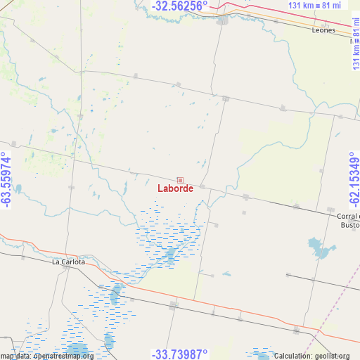
Laborde GPS coordinates[2]
33° 9' 11.484" South, 62° 51' 23.796" West
| Map corner | latitude | longitude |
|---|---|---|
| Upper-left | -32.56256°, | -63.55974° |
| Center: | -33.15319°, | -62.85661° |
| Lower-right: | -33.73987°, | -62.15349° |
| Map W x H: | 130.9×130.9 km | = 81.3×81.3mi |
| max Lat: | -21.94467° ⇑63.8% North |
| Laborde: | -33.15319° |
| min Lat: | ⇓36.2% South -54.81084° |
| min Long | Laborde | max Long |
| -72.88605° | -62.85661° | -53.64581° |
| W 49%⇐ | ⇒51% E |
Elevation
Elevation of Laborde is 127 m = 417 ft, and this is 222.3 m = 729 ft below average elevation for this country.
| Max E: |
4040 m = 13255 ft | 54% |
| Avg. | 349.3 m = 1146 ft | |
| Laborde | 127 m = 417 ft | |
Min E: |
-2 m = -7 ft | 46% |
See also: Argentina elevation on elevation.city.
Geographical zone
Laborde is located in South temperate zone (between Tropic of Capricorn and the Antarctic Circle). Distance of this Southern Tropic circle is 1080.4 km =671.3 mi to North.| Distance of | km | miles | from Laborde |
|---|---|---|---|
| Equator | 3686.3 | 2290.6 | to North |
| Tropic Capricorn | 1080.4 | 671.3 | to North |
| Antarctic Circle | 3714.9 | 2308.3 | to South |
| South Pole | 6320.8 | 3927.6 | to South |


Nearby cities:
15 places around Laborde: (largest is in red/bold)
• Canals
45.9 km =28.5 mi,  183°
183°
• Chazón
40 km =24.9 mi,  281°
281°
• Etruria
43.4 km =27 mi,  303°
303°
• General Baldissera
51.4 km =31.9 mi,  86°
86°
• Guatimozín
51.8 km =32.2 mi,  131°
131°
• Idiazábal
41.1 km =25.5 mi,  336°
336°
• Isla Verde
43.3 km =26.9 mi,  103°
103°
• Justiniano Posse
34.2 km =21.3 mi,  29°
29°
• La Carlota
50.6 km =31.4 mi,  234°
234°
• Monte Buey
45.6 km =28.3 mi,  54°
54°
• Monte Maíz
24.5 km =15.2 mi, 103°
• Ordóñez
34.8 km =21.6 mi,  358°
358°
• Pascanas
17.4 km =10.8 mi, 280°
• Santa Eufemia
39.8 km =24.7 mi,  266°
266°
• Wenceslao Escalante
8.3 km =5.2 mi,  105°
105°
Sources, notices
• [Note1] Compared only with cities in Argentina existing in our database
• [Src1] Map data: © OpenStreetMap contributors (CC-BY-SA)
• [Src2] Other city data from geonames.org with taken over terms of usage.
• [Src3] Geographical zone / Annual Mean Temperature by Robert A. Rohde @ Wikipedia
