Totoras geodata
Totoras (Santa Fe) is a populated place; located in Argentina in America/Argentina/Cordoba (GMT-3) time zone. With population of 9,587 people, there are 300 cities with bigger population in this country. Compared to other cities in Argentina, 57.3% of cities are located further ↑North; 60% of cities are located further ←West and 81% of cities have higher elevation than Totoras. Note1


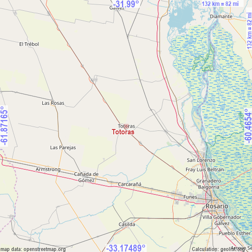
Totoras GPS coordinates[2]
32° 35' 3.84" South, 61° 10' 6.672" West
| Map corner | latitude | longitude |
|---|---|---|
| Upper-left | -31.99°, | -61.87165° |
| Center: | -32.5844°, | -61.16852° |
| Lower-right: | -33.17489°, | -60.4654° |
| Map W x H: | 131.7×131.7 km | = 81.8×81.8mi |
| max Lat: | -21.94467° ⇑57.3% North |
| Totoras: | -32.5844° |
| min Lat: | ⇓42.7% South -54.81084° |
| min Long | Totoras | max Long |
| -72.88605° | -61.16852° | -53.64581° |
| W 60%⇐ | ⇒40% E |
Elevation
Elevation of Totoras is 56 m = 184 ft, and this is 293.3 m = 962 ft below average elevation for this country.
| Max E: |
4040 m = 13255 ft | 81% |
| Avg. | 349.3 m = 1146 ft | |
| Totoras | 56 m = 184 ft | |
Min E: |
-2 m = -7 ft | 19% |
See also: Argentina elevation on elevation.city.
Geographical zone
Totoras is located in South temperate zone (between Tropic of Capricorn and the Antarctic Circle). Distance of this Southern Tropic circle is 1017.1 km =632 mi to North.| Distance of | km | miles | from Totoras |
|---|---|---|---|
| Equator | 3623 | 2251.2 | to North |
| Tropic Capricorn | 1017.1 | 632 | to North |
| Antarctic Circle | 3778.1 | 2347.6 | to South |
| South Pole | 6384 | 3966.8 | to South |


Nearby cities:
15 places around Totoras: (largest is in red/bold)
• Armstrong
46.2 km =28.7 mi,  241°
241°
• Capitán Bermúdez
49.7 km =30.9 mi,  122°
122°
• Carcarañá
30.3 km =18.8 mi,  177°
177°
• Casilda
51.1 km =31.8 mi, 179°
• Cañada de Gómez
33.4 km =20.8 mi,  219°
219°
• Fray Luis A. Beltrán
47.2 km =29.3 mi, 119°
• Funes
49.8 km =30.9 mi,  137°
137°
• Granadero Baigorria
51.9 km =32.2 mi,  125°
125°
• Gálvez
61.9 km =38.5 mi,  355°
355°
• Las Parejas
34.4 km =21.4 mi,  251°
251°
• Las Rosas
40.4 km =25.1 mi,  287°
287°
• Pérez
59.3 km =36.8 mi, 140°
• Roldán
42.6 km =26.5 mi, 144°
• Rosario
63.8 km =39.6 mi, 129°
• San Lorenzo
44.2 km =27.5 mi,  113°
113°
Sources, notices
• [Note1] Compared only with cities in Argentina existing in our database
• [Src1] Map data: © OpenStreetMap contributors (CC-BY-SA)
• [Src2] Other city data from geonames.org with taken over terms of usage.
• [Src3] Geographical zone / Annual Mean Temperature by Robert A. Rohde @ Wikipedia
