Aluminé geodata
Aluminé (Neuquen) is a seat of a second-order administrative division; located in Argentina in America/Argentina/Salta (GMT-3) time zone. With population of 3,720 people, there are 508 cities with bigger population in this country. Compared to other cities in Argentina, 93.1% of cities are located further ↑North; 98.1% of cities are located further →East and 91.4% of cities have lower elevation than Aluminé. Note1


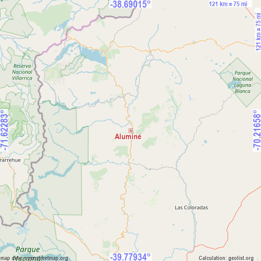
Aluminé GPS coordinates[2]
39° 14' 12.696" South, 70° 55' 10.92" West
| Map corner | latitude | longitude |
|---|---|---|
| Upper-left | -38.69015°, | -71.62283° |
| Center: | -39.23686°, | -70.9197° |
| Lower-right: | -39.77934°, | -70.21658° |
| Map W x H: | 121.1×121.1 km | = 75.2×75.2mi |
| max Lat: | -21.94467° ⇑93.1% North |
| Aluminé: | -39.23686° |
| min Lat: | ⇓6.9% South -54.81084° |
| min Long | Aluminé | max Long |
| -72.88605° | -70.9197° | -53.64581° |
| W 1.9%⇐ | ⇒98.1% E |
Elevation
Elevation of Aluminé is 937 m = 3074 ft, and this is 587.7 m = 1928 ft above average elevation for this country.
| Max E: |
4040 m = 13255 ft | 8.6% |
| Aluminé | 937 m 3074 ft | |
| Avg. | 349.3 m = 1146 ft | |
Min E: |
-2 m = -7 ft | 91.4% |
See also: Argentina elevation on elevation.city.
Geographical zone
Aluminé is located in South temperate zone (between Tropic of Capricorn and the Antarctic Circle). Distance of this Southern Tropic circle is 1756.8 km =1091.6 mi to North.| Distance of | km | miles | from Aluminé |
|---|---|---|---|
| Equator | 4362.7 | 2710.9 | to North |
| Tropic Capricorn | 1756.8 | 1091.6 | to North |
| Antarctic Circle | 3038.4 | 1888 | to South |
| South Pole | 5644.3 | 3507.2 | to South |


Nearby cities:
15 places around Aluminé: (largest is in red/bold)
• Añelo
209.1 km =129.9 mi,  62°
62°
• Comallo
206.9 km =128.6 mi,  164°
164°
• Cutral-Có
149.6 km =93 mi,  77°
77°
• El Huecú
179.4 km =111.5 mi,  9°
9°
• Junín de los Andes
80.4 km =50 mi,  189°
189°
• Las Coloradas
45.1 km =28 mi,  141°
141°
• Las Lajas
92.6 km =57.5 mi,  31°
31°
• Loncopué
132.1 km =82.1 mi, 11°
• Mariano Moreno
94.5 km =58.7 mi, 55°
• Picún Leufú
143.7 km =89.3 mi,  102°
102°
• Piedra del Águila
115.7 km =71.9 mi, 141°
• Plaza Huincul
151.7 km =94.3 mi, 76°
• San Martín de los Andes
108.9 km =67.7 mi,  199°
199°
• Villa La Angostura
180.5 km =112.2 mi, 200°
• Zapala
83.6 km =51.9 mi, 63°
Sources, notices
• [Note1] Compared only with cities in Argentina existing in our database
• [Src1] Map data: © OpenStreetMap contributors (CC-BY-SA)
• [Src2] Other city data from geonames.org with taken over terms of usage.
• [Src3] Geographical zone / Annual Mean Temperature by Robert A. Rohde @ Wikipedia
