Piedra del Águila geodata
Piedra del Águila (Neuquen) is a seat of a second-order administrative division; located in Argentina in America/Argentina/Salta (GMT-3) time zone. With population of 3,372 people, there are 531 cities with bigger population in this country. Compared to other cities in Argentina, 93.9% of cities are located further ↑North; 96.4% of cities are located further →East and 77.4% of cities have lower elevation than Piedra del Águila. Note1


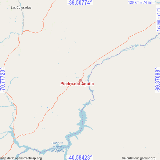
Piedra del Águila GPS coordinates[2]
40° 2' 53.196" South, 70° 4' 26.76" West
| Map corner | latitude | longitude |
|---|---|---|
| Upper-left | -39.50774°, | -70.77723° |
| Center: | -40.04811°, | -70.0741° |
| Lower-right: | -40.58423°, | -69.37098° |
| Map W x H: | 119.7×119.7 km | = 74.4×74.4mi |
| max Lat: | -21.94467° ⇑93.9% North |
| Piedra del Águila: | -40.04811° |
| min Lat: | ⇓6.1% South -54.81084° |
| min Long | Piedra del Águ | max Long |
| -72.88605° | -70.0741° | -53.64581° |
| W 3.6%⇐ | ⇒96.4% E |
Elevation
Elevation of Piedra del Águila is 505 m = 1657 ft, and this is 155.7 m = 511 ft above average elevation for this country.
| Max E: |
4040 m = 13255 ft | 22.6% |
| Piedra del Águila | 505 m 1657 ft | |
| Avg. | 349.3 m = 1146 ft | |
Min E: |
-2 m = -7 ft | 77.4% |
See also: Argentina elevation on elevation.city.
Geographical zone
Piedra del Águila is located in South temperate zone (between Tropic of Capricorn and the Antarctic Circle). Distance of this Southern Tropic circle is 1847 km =1147.7 mi to North.| Distance of | km | miles | from Piedra del Águila |
|---|---|---|---|
| Equator | 4452.9 | 2766.9 | to North |
| Tropic Capricorn | 1847 | 1147.7 | to North |
| Antarctic Circle | 2948.2 | 1831.9 | to South |
| South Pole | 5554.1 | 3451.2 | to South |


Nearby cities:
15 places around Piedra del Águila: (largest is in red/bold)
• Aluminé
115.7 km =71.9 mi,  321°
321°
• Comallo
110.4 km =68.6 mi,  188°
188°
• Cutral-Có
143.5 km =89.2 mi,  30°
30°
• El Cuy
148.2 km =92.1 mi,  84°
84°
• Ingeniero Jacobacci
149.1 km =92.6 mi,  162°
162°
• Junín de los Andes
85.5 km =53.1 mi,  277°
277°
• Las Coloradas
70.6 km =43.9 mi, 320°
• Mariano Moreno
144.4 km =89.7 mi,  1°
1°
• Picún Leufú
89.5 km =55.6 mi,  48°
48°
• Pilcaniyeu
131.4 km =81.6 mi,  204°
204°
• Plaza Huincul
145.2 km =90.2 mi, 30°
• San Carlos de Bariloche
160.5 km =99.7 mi,  220°
220°
• San Martín de los Andes
109.5 km =68 mi,  263°
263°
• Villa La Angostura
155 km =96.3 mi,  239°
239°
• Zapala
127.8 km =79.4 mi, 0°
Sources, notices
• [Note1] Compared only with cities in Argentina existing in our database
• [Src1] Map data: © OpenStreetMap contributors (CC-BY-SA)
• [Src2] Other city data from geonames.org with taken over terms of usage.
• [Src3] Geographical zone / Annual Mean Temperature by Robert A. Rohde @ Wikipedia
