Wienersdorf geodata
Wienersdorf (Lower Austria) is a populated place; located in Austria in Europe/Vienna (GMT+2) time zone. With population of 2,971 people, there are 385 cities with bigger population in this country. Compared to other cities in Austria, 66.8% of cities are located further ↓South; 88.5% of cities are located further ←West and 91.6% of cities have higher elevation than Wienersdorf. Note1
Administrative division(s):
- Level 1: Lower Austria
- Level 2: Politischer Bezirk Baden
- Level 3: Traiskirchen


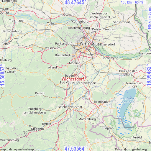
Wienersdorf GPS coordinates[2]
48° 0' 29.484" North, 16° 17' 30.084" East
| Map corner | latitude | longitude |
|---|---|---|
| Upper-left | 48.47645°, | 15.58857° |
| Center: | 48.00819°, | 16.29169° |
| Lower-right: | 47.53564°, | 16.99482° |
| Map W x H: | 104.6×104.6 km | = 65×65mi |
| max Lat: | 48.98333° ⇑33.2% North |
| Wienersdorf: | 48.00819° |
| min Lat: | ⇓66.8% South 46.48841° |
| min Long | Wienersdorf | max Long |
| 9.57802° | 16.29169° | 17.1° |
| W 88.5%⇐ | ⇒11.5% E |
Elevation
Elevation of Wienersdorf is 204 m = 669 ft, and this is 301.5 m = 989 ft below average elevation for this country.
| Max E: |
2140 m = 7021 ft | 91.6% |
| Avg. | 505.5 m = 1658 ft | |
| Wienersdorf | 204 m = 669 ft | |
Min E: |
118 m = 387 ft | 8.4% |
See also: Austria elevation on elevation.city.
Geographical zone
Wienersdorf is located in North temperate zone (between Tropic of Cancer and the Arctic Circle). Distance of this North polar circle is 2063.2 km =1282 mi to North.| Distance of | km | miles | from Wienersdorf |
|---|---|---|---|
| North Pole | 4669.1 | 2901.2 | to North |
| Arctic Circle | 2063.2 | 1282 | to North |
| Tropic Cancer | 2732.1 | 1697.6 | to South |
| Equator | 5338 | 3316.9 | to South |


Nearby cities:
15 places around Wienersdorf: (largest is in red/bold)
• Baden
4.4 km =2.7 mi,  266°
266°
• Gumpoldskirchen
4.3 km =2.7 mi,  345°
345°
• Guntramsdorf
4.6 km =2.9 mi,  20°
20°
• Möllersdorf
2.2 km =1.4 mi,  27°
27°
• Münchendorf
7.4 km =4.6 mi,  67°
67°
• Neu-Guntramsdorf
6.5 km =4 mi, 16°
• Oberwaltersdorf
4.3 km =2.7 mi,  148°
148°
• Oeynhausen
2.5 km =1.6 mi,  179°
179°
• Pfaffstätten
2.3 km =1.4 mi,  295°
295°
• Sooss
6.1 km =3.8 mi,  244°
244°
• Tattendorf
6.5 km =4 mi,  174°
174°
• Teesdorf
6.5 km =4 mi,  185°
185°
• Traiskirchen
0.7 km =0.4 mi,  8°
8°
• Tribuswinkel
1.6 km =1 mi,  262°
262°
• Trumau
4.1 km =2.5 mi,  113°
113°
Sources, notices
• [Note1] Compared only with cities in Austria existing in our database
• [Src1] Map data: © OpenStreetMap contributors (CC-BY-SA)
• [Src2] Other city data from geonames.org with taken over terms of usage.
• [Src3] Geographical zone / Annual Mean Temperature by Robert A. Rohde @ Wikipedia
