Trumau geodata
Trumau (Lower Austria) is a seat of a third-order administrative division; located in Austria in Europe/Vienna (GMT+2) time zone. With population of 3,640 people, there are 295 cities with bigger population in this country. Compared to other cities in Austria, 65.7% of cities are located further ↓South; 89.7% of cities are located further ←West and 92% of cities have higher elevation than Trumau. Note1
Administrative division(s):
- Level 1: Lower Austria
- Level 2: Politischer Bezirk Baden
- Level 3: Trumau


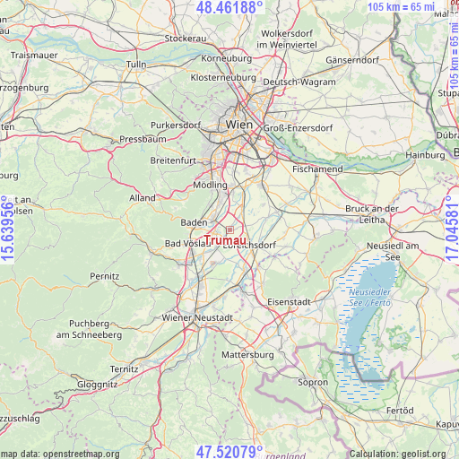
Trumau GPS coordinates[2]
47° 59' 36.528" North, 16° 20' 33.648" East
| Map corner | latitude | longitude |
|---|---|---|
| Upper-left | 48.46188°, | 15.63956° |
| Center: | 47.99348°, | 16.34268° |
| Lower-right: | 47.52079°, | 17.04581° |
| Map W x H: | 104.6×104.6 km | = 65×65mi |
| max Lat: | 48.98333° ⇑34.3% North |
| Trumau: | 47.99348° |
| min Lat: | ⇓65.7% South 46.48841° |
| min Long | Trumau | max Long |
| 9.57802° | 16.34268° | 17.1° |
| W 89.7%⇐ | ⇒10.3% E |
Elevation
Elevation of Trumau is 201 m = 659 ft, and this is 304.5 m = 999 ft below average elevation for this country.
| Max E: |
2140 m = 7021 ft | 92% |
| Avg. | 505.5 m = 1658 ft | |
| Trumau | 201 m = 659 ft | |
Min E: |
118 m = 387 ft | 8% |
See also: Austria elevation on elevation.city.
Geographical zone
Trumau is located in North temperate zone (between Tropic of Cancer and the Arctic Circle). Distance of this North polar circle is 2064.8 km =1283 mi to North.| Distance of | km | miles | from Trumau |
|---|---|---|---|
| North Pole | 4670.7 | 2902.2 | to North |
| Arctic Circle | 2064.8 | 1283 | to North |
| Tropic Cancer | 2730.5 | 1696.7 | to South |
| Equator | 5336.4 | 3315.9 | to South |


Nearby cities:
15 places around Trumau: (largest is in red/bold)
• Ebreichsdorf
6.4 km =4 mi,  131°
131°
• Gumpoldskirchen
7.6 km =4.7 mi,  319°
319°
• Guntramsdorf
6.3 km =3.9 mi,  340°
340°
• Möllersdorf
4.5 km =2.8 mi, 322°
• Münchendorf
5.4 km =3.4 mi,  34°
34°
• Oberwaltersdorf
2.5 km =1.6 mi,  217°
217°
• Oeynhausen
3.9 km =2.4 mi,  256°
256°
• Pfaffstätten
6.5 km =4 mi,  294°
294°
• Tattendorf
5.8 km =3.6 mi,  213°
213°
• Teesdorf
6.5 km =4 mi, 222°
• Traiskirchen
4.4 km =2.7 mi,  302°
302°
• Tribuswinkel
5.5 km =3.4 mi,  284°
284°
• Unterwaltersdorf
7.3 km =4.5 mi, 131°
• Weigelsdorf
6.4 km =4 mi,  138°
138°
• Wienersdorf
4.1 km =2.5 mi, 293°
Sources, notices
• [Note1] Compared only with cities in Austria existing in our database
• [Src1] Map data: © OpenStreetMap contributors (CC-BY-SA)
• [Src2] Other city data from geonames.org with taken over terms of usage.
• [Src3] Geographical zone / Annual Mean Temperature by Robert A. Rohde @ Wikipedia
