Weyregg geodata
Weyregg (Upper Austria) is a seat of a third-order administrative division; located in Austria in Europe/Vienna (GMT+2) time zone. With population of 799 people, there are 1617 cities with bigger population in this country. Compared to other cities in Austria, 61.4% of cities are located further ↓South; 73.9% of cities are located further →East and 54% of cities have lower elevation than Weyregg. Note1
Administrative division(s):
- Level 1: Upper Austria
- Level 2: Politischer Bezirk Vöcklabruck
- Level 3: Weyregg am Attersee


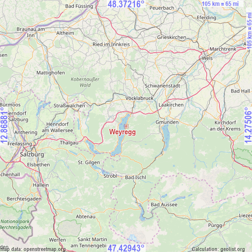
Weyregg GPS coordinates[2]
47° 54' 10.584" North, 13° 34' 18.948" East
| Map corner | latitude | longitude |
|---|---|---|
| Upper-left | 48.37216°, | 12.86881° |
| Center: | 47.90294°, | 13.57193° |
| Lower-right: | 47.42943°, | 14.27506° |
| Map W x H: | 104.8×104.8 km | = 65.1×65.1mi |
| max Lat: | 48.98333° ⇑38.6% North |
| Weyregg: | 47.90294° |
| min Lat: | ⇓61.4% South 46.48841° |
| min Long | Weyregg | max Long |
| 9.57802° | 13.57193° | 17.1° |
| W 26.1%⇐ | ⇒73.9% E |
Elevation
Elevation of Weyregg is 477 m = 1565 ft, and this is 28.5 m = 94 ft below average elevation for this country.
| Max E: |
2140 m = 7021 ft | 46% |
| Avg. | 505.5 m = 1658 ft | |
| Weyregg | 477 m = 1565 ft | |
Min E: |
118 m = 387 ft | 54% |
See also: Austria elevation on elevation.city.
Geographical zone
Weyregg is located in North temperate zone (between Tropic of Cancer and the Arctic Circle). Distance of this North polar circle is 2074.9 km =1289.3 mi to North.| Distance of | km | miles | from Weyregg |
|---|---|---|---|
| North Pole | 4680.8 | 2908.5 | to North |
| Arctic Circle | 2074.9 | 1289.3 | to North |
| Tropic Cancer | 2720.4 | 1690.4 | to South |
| Equator | 5326.3 | 3309.6 | to South |


Nearby cities:
15 places around Weyregg: (largest is in red/bold)
• Alt Lenzing
8.3 km =5.2 mi,  28°
28°
• Attersee
2.8 km =1.7 mi,  301°
301°
• Aurach am Hongar
9.3 km =5.8 mi,  54°
54°
• Gampern
9.6 km =6 mi,  352°
352°
• Lenzing
8.3 km =5.2 mi,  19°
19°
• Neukirchen
10.8 km =6.7 mi,  106°
106°
• Nussdorf am Attersee
4.7 km =2.9 mi,  242°
242°
• Oberhehenfeld
4.9 km =3 mi, 54°
• Oberwang
11.1 km =6.9 mi,  248°
248°
• Pichlwang
10.5 km =6.5 mi, 18°
• Sankt Georgen im Attergau
7.6 km =4.7 mi, 298°
• Schörfling
5.3 km =3.3 mi, 26°
• Seewalchen
5.6 km =3.5 mi,  9°
9°
• Steinbach am Attersee
8.2 km =5.1 mi,  193°
193°
• Steindorf
6.6 km =4.1 mi,  359°
359°
Sources, notices
• [Note1] Compared only with cities in Austria existing in our database
• [Src1] Map data: © OpenStreetMap contributors (CC-BY-SA)
• [Src2] Other city data from geonames.org with taken over terms of usage.
• [Src3] Geographical zone / Annual Mean Temperature by Robert A. Rohde @ Wikipedia
