Oberhehenfeld geodata
Oberhehenfeld (Upper Austria) is a populated place; located in Austria in Europe/Vienna (GMT+2) time zone. With population of 830 people, there are 1555 cities with bigger population in this country. Compared to other cities in Austria, 62.1% of cities are located further ↓South; 73% of cities are located further →East and 60.2% of cities have lower elevation than Oberhehenfeld. Note1
Administrative division(s):
- Level 1: Upper Austria
- Level 2: Politischer Bezirk Vöcklabruck
- Level 3: Schörfling am Attersee


Oberhehenfeld GPS coordinates[2]
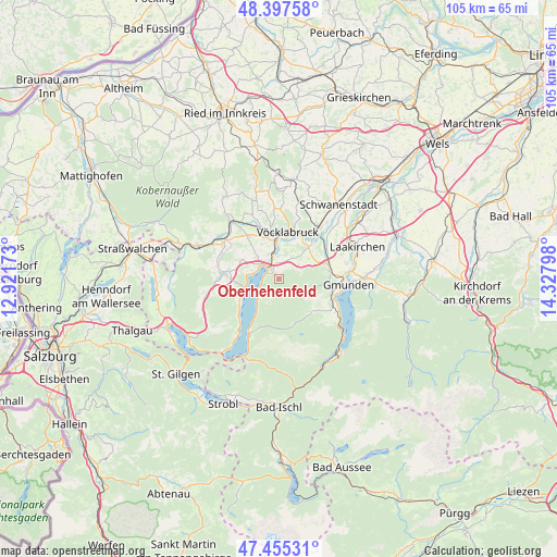
47° 55' 42.924" North, 13° 37' 29.46" East
| Map corner | latitude | longitude |
|---|---|---|
| Upper-left | 48.39758°, | 12.92173° |
| Center: | 47.92859°, | 13.62485° |
| Lower-right: | 47.45531°, | 14.32798° |
| Map W x H: | 104.8×104.8 km | = 65.1×65.1mi |
| max Lat: | 48.98333° ⇑37.9% North |
| Oberhehenfeld: | 47.92859° |
| min Lat: | ⇓62.1% South 46.48841° |
| min Long | Oberhehenfeld | max Long |
| 9.57802° | 13.62485° | 17.1° |
| W 27%⇐ | ⇒73% E |
Elevation
Elevation of Oberhehenfeld is 518 m = 1699 ft, and this is 12.5 m = 41 ft above average elevation for this country.
| Max E: |
2140 m = 7021 ft | 39.8% |
| Oberhehenfeld | 518 m 1699 ft | |
| Avg. | 505.5 m = 1658 ft | |
Min E: |
118 m = 387 ft | 60.2% |
See also: Austria elevation on elevation.city.
Geographical zone
Oberhehenfeld is located in North temperate zone (between Tropic of Cancer and the Arctic Circle). Distance of this North polar circle is 2072 km =1287.5 mi to North.| Distance of | km | miles | from Oberhehenfeld |
|---|---|---|---|
| North Pole | 4677.9 | 2906.7 | to North |
| Arctic Circle | 2072 | 1287.5 | to North |
| Tropic Cancer | 2723.2 | 1692.1 | to South |
| Equator | 5329.2 | 3311.4 | to South |


Nearby cities:
15 places around Oberhehenfeld: (largest is in red/bold)
• Alt Lenzing
4.5 km =2.8 mi,  0°
0°
• Attersee
6.5 km =4 mi,  258°
258°
• Aurach am Hongar
4.4 km =2.7 mi,  54°
54°
• Dürnau
7.8 km =4.8 mi,  10°
10°
• Großkufhaus
8.4 km =5.2 mi,  95°
95°
• Lenzing
5.1 km =3.2 mi,  346°
346°
• Lixlau
7.8 km =4.8 mi,  20°
20°
• Pichlwang
7.1 km =4.4 mi, 354°
• Regau
8.4 km =5.2 mi,  34°
34°
• Rutzenmoos
8 km =5 mi, 50°
• Schöndorf
8.5 km =5.3 mi, 17°
• Schörfling
2.4 km =1.5 mi,  320°
320°
• Seewalchen
4 km =2.5 mi,  310°
310°
• Steindorf
5.5 km =3.4 mi, 313°
• Weyregg
4.9 km =3 mi,  234°
234°
Sources, notices
• [Note1] Compared only with cities in Austria existing in our database
• [Src1] Map data: © OpenStreetMap contributors (CC-BY-SA)
• [Src2] Other city data from geonames.org with taken over terms of usage.
• [Src3] Geographical zone / Annual Mean Temperature by Robert A. Rohde @ Wikipedia
