Attersee geodata
Attersee (Upper Austria) is a seat of a third-order administrative division; located in Austria in Europe/Vienna (GMT+1) time zone. With population of 401 people, there are 2615 cities with bigger population in this country. Compared to other cities in Austria, 61.7% of cities are located further ↓South; 74.4% of cities are located further →East and 55.7% of cities have lower elevation than Attersee. Note1
Administrative division(s):
- Level 1: Upper Austria
- Level 2: Politischer Bezirk Vöcklabruck
- Level 3: Attersee


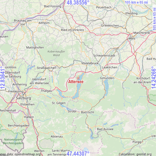
Attersee GPS coordinates[2]
47° 54' 59.256" North, 13° 32' 22.308" East
| Map corner | latitude | longitude |
|---|---|---|
| Upper-left | 48.38556°, | 12.83641° |
| Center: | 47.91646°, | 13.53953° |
| Lower-right: | 47.44307°, | 14.24266° |
| Map W x H: | 104.8×104.8 km | = 65.1×65.1mi |
| max Lat: | 48.98333° ⇑38.3% North |
| Attersee: | 47.91646° |
| min Lat: | ⇓61.7% South 46.48841° |
| min Long | Attersee | max Long |
| 9.57802° | 13.53953° | 17.1° |
| W 25.6%⇐ | ⇒74.4% E |
Elevation
Elevation of Attersee is 490 m = 1608 ft, and this is 15.5 m = 51 ft below average elevation for this country.
| Max E: |
2140 m = 7021 ft | 44.3% |
| Avg. | 505.5 m = 1658 ft | |
| Attersee | 490 m = 1608 ft | |
Min E: |
118 m = 387 ft | 55.7% |
See also: Austria elevation on elevation.city.
Geographical zone
Attersee is located in North temperate zone (between Tropic of Cancer and the Arctic Circle). Distance of this North polar circle is 2073.4 km =1288.4 mi to North.| Distance of | km | miles | from Attersee |
|---|---|---|---|
| North Pole | 4679.3 | 2907.6 | to North |
| Arctic Circle | 2073.4 | 1288.4 | to North |
| Tropic Cancer | 2721.9 | 1691.3 | to South |
| Equator | 5327.8 | 3310.5 | to South |


Nearby cities:
15 places around Attersee: (largest is in red/bold)
• Alt Lenzing
8.6 km =5.3 mi,  47°
47°
• Gampern
8.1 km =5 mi,  7°
7°
• Lenzing
8.1 km =5 mi,  39°
39°
• Nussdorf am Attersee
4.1 km =2.5 mi,  204°
204°
• Oberhehenfeld
6.5 km =4 mi,  78°
78°
• Oberwang
9.7 km =6 mi,  235°
235°
• Pichlwang
10.2 km =6.3 mi,  33°
33°
• Sankt Georgen im Attergau
4.7 km =2.9 mi,  297°
297°
• Schörfling
5.8 km =3.6 mi,  56°
56°
• Seewalchen
5.2 km =3.2 mi, 39°
• Steinbach am Attersee
9.5 km =5.9 mi,  177°
177°
• Steindorf
5.6 km =3.5 mi,  24°
24°
• Vöcklamarkt
10.4 km =6.5 mi,  336°
336°
• Weißenkirchen im Attergau
9.7 km =6 mi,  292°
292°
• Weyregg
2.8 km =1.7 mi,  121°
121°
Sources, notices
• [Note1] Compared only with cities in Austria existing in our database
• [Src1] Map data: © OpenStreetMap contributors (CC-BY-SA)
• [Src2] Other city data from geonames.org with taken over terms of usage.
• [Src3] Geographical zone / Annual Mean Temperature by Robert A. Rohde @ Wikipedia
