Werndorf geodata
Werndorf (Styria) is a seat of a third-order administrative division; located in Austria in Europe/Vienna (GMT+2) time zone. With population of 2,365 people, there are 517 cities with bigger population in this country. Compared to other cities in Austria, 87.4% of cities are located further ↑North; 65.3% of cities are located further ←West and 74.1% of cities have higher elevation than Werndorf. Note1
Administrative division(s):
- Level 1: Styria
- Level 2: Politischer Bezirk Graz-Umgebung
- Level 3: Werndorf


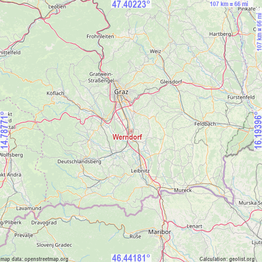
Werndorf GPS coordinates[2]
46° 55' 27.012" North, 15° 29' 26.988" East
| Map corner | latitude | longitude |
|---|---|---|
| Upper-left | 47.40223°, | 14.78771° |
| Center: | 46.92417°, | 15.49083° |
| Lower-right: | 46.44181°, | 16.19396° |
| Map W x H: | 106.8×106.8 km | = 66.4×66.4mi |
| max Lat: | 48.98333° ⇑87.4% North |
| Werndorf: | 46.92417° |
| min Lat: | ⇓12.6% South 46.48841° |
| min Long | Werndorf | max Long |
| 9.57802° | 15.49083° | 17.1° |
| W 65.3%⇐ | ⇒34.7% E |
Elevation
Elevation of Werndorf is 309 m = 1014 ft, and this is 196.5 m = 645 ft below average elevation for this country.
| Max E: |
2140 m = 7021 ft | 74.1% |
| Avg. | 505.5 m = 1658 ft | |
| Werndorf | 309 m = 1014 ft | |
Min E: |
118 m = 387 ft | 25.9% |
See also: Austria elevation on elevation.city.
Geographical zone
Werndorf is located in North temperate zone (between Tropic of Cancer and the Arctic Circle). Distance of this North polar circle is 2183.7 km =1356.9 mi to North.| Distance of | km | miles | from Werndorf |
|---|---|---|---|
| North Pole | 4789.6 | 2976.1 | to North |
| Arctic Circle | 2183.7 | 1356.9 | to North |
| Tropic Cancer | 2611.6 | 1622.8 | to South |
| Equator | 5217.5 | 3242 | to South |


Nearby cities:
15 places around Werndorf: (largest is in red/bold)
• Allerheiligen bei Wildon
5 km =3.1 mi,  102°
102°
• Bierbaum
7.1 km =4.4 mi,  309°
309°
• Felgitsch
6.8 km =4.2 mi,  79°
79°
• Fernitz
5.6 km =3.5 mi,  8°
8°
• Grosssulz
2.4 km =1.5 mi,  358°
358°
• Kalsdorf bei Graz
4.6 km =2.9 mi,  350°
350°
• Laa
6.3 km =3.9 mi,  297°
297°
• Mellach
2.2 km =1.4 mi,  62°
62°
• Sankt Margarethen bei Lebring
7.3 km =4.5 mi,  157°
157°
• Sankt Ulrich am Waasen
3.4 km =2.1 mi,  72°
72°
• Wagnitz
6.8 km =4.2 mi,  344°
344°
• Weitendorf
3.6 km =2.2 mi,  210°
210°
• Wildon
4.9 km =3 mi, 156°
• Wundschuh
3 km =1.9 mi,  274°
274°
• Zettling
5.3 km =3.3 mi, 305°
Sources, notices
• [Note1] Compared only with cities in Austria existing in our database
• [Src1] Map data: © OpenStreetMap contributors (CC-BY-SA)
• [Src2] Other city data from geonames.org with taken over terms of usage.
• [Src3] Geographical zone / Annual Mean Temperature by Robert A. Rohde @ Wikipedia
