Fernitz geodata
Fernitz (Styria) is a seat of a third-order administrative division; located in Austria in Europe/Vienna (GMT+2) time zone. With population of 3,119 people, there are 359 cities with bigger population in this country. Compared to other cities in Austria, 85.4% of cities are located further ↑North; 65.7% of cities are located further ←West and 71.5% of cities have higher elevation than Fernitz. Note1
Administrative division(s):
- Level 1: Styria
- Level 2: Politischer Bezirk Graz-Umgebung
- Level 3: Fernitz-Mellach


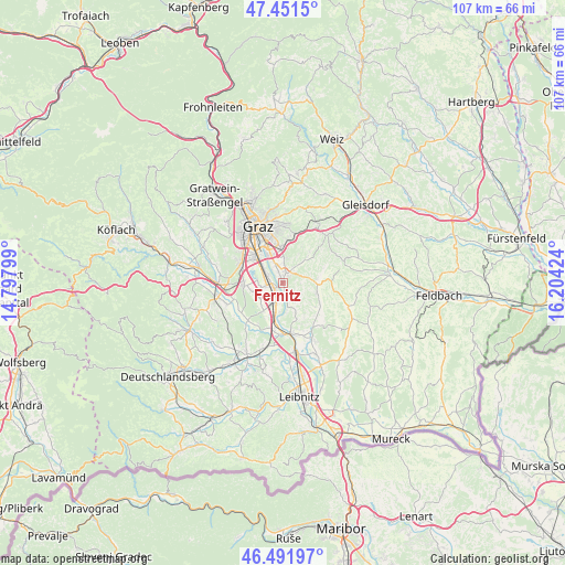
Fernitz GPS coordinates[2]
46° 58' 26.004" North, 15° 30' 3.996" East
| Map corner | latitude | longitude |
|---|---|---|
| Upper-left | 47.4515°, | 14.79799° |
| Center: | 46.97389°, | 15.50111° |
| Lower-right: | 46.49197°, | 16.20424° |
| Map W x H: | 106.7×106.7 km | = 66.3×66.3mi |
| max Lat: | 48.98333° ⇑85.4% North |
| Fernitz: | 46.97389° |
| min Lat: | ⇓14.6% South 46.48841° |
| min Long | Fernitz | max Long |
| 9.57802° | 15.50111° | 17.1° |
| W 65.7%⇐ | ⇒34.3% E |
Elevation
Elevation of Fernitz is 321 m = 1053 ft, and this is 184.5 m = 605 ft below average elevation for this country.
| Max E: |
2140 m = 7021 ft | 71.5% |
| Avg. | 505.5 m = 1658 ft | |
| Fernitz | 321 m = 1053 ft | |
Min E: |
118 m = 387 ft | 28.5% |
See also: Austria elevation on elevation.city.
Geographical zone
Fernitz is located in North temperate zone (between Tropic of Cancer and the Arctic Circle). Distance of this North polar circle is 2178.2 km =1353.5 mi to North.| Distance of | km | miles | from Fernitz |
|---|---|---|---|
| North Pole | 4784.1 | 2972.7 | to North |
| Arctic Circle | 2178.2 | 1353.5 | to North |
| Tropic Cancer | 2617.1 | 1626.2 | to South |
| Equator | 5223 | 3245.4 | to South |


Nearby cities:
15 places around Fernitz: (largest is in red/bold)
• Abtissendorf
4.2 km =2.6 mi,  305°
305°
• Dörfla
3.9 km =2.4 mi,  318°
318°
• Grambach
4.5 km =2.8 mi,  2°
2°
• Grosssulz
3.3 km =2.1 mi,  194°
194°
• Gössendorf
3 km =1.9 mi,  336°
336°
• Hausmannstätten
2.1 km =1.3 mi,  22°
22°
• Kalsdorf bei Graz
1.8 km =1.1 mi,  238°
238°
• Lebern
4.8 km =3 mi, 306°
• Liebensdorf
5.1 km =3.2 mi,  79°
79°
• Mellach
4.7 km =2.9 mi,  165°
165°
• Sankt Ulrich am Waasen
5.1 km =3.2 mi,  151°
151°
• Thondorf
4.6 km =2.9 mi,  334°
334°
• Wagnitz
2.8 km =1.7 mi,  291°
291°
• Werndorf
5.6 km =3.5 mi, 188°
• Zettling
5.6 km =3.5 mi, 244°
Sources, notices
• [Note1] Compared only with cities in Austria existing in our database
• [Src1] Map data: © OpenStreetMap contributors (CC-BY-SA)
• [Src2] Other city data from geonames.org with taken over terms of usage.
• [Src3] Geographical zone / Annual Mean Temperature by Robert A. Rohde @ Wikipedia
